April 28, 1805
[Lewis]
Set out this morning at an early hour; the wind was favourable and we employed our sails to advantage. Capt Clark walked on shore this morning, [1] and I proceeded with the party. the country through which we passed today is open as usual and very broken on both sides near the river hills, the bottoms are level fertile and partially covered with timber. the hills and bluffs exhibit their usual mineral appearances, some birnt hills but no appearance of Pumicestone; coal is in great abundance and the salts still increase in quantity; the banks of the river and sandbars are incrusted with it in many places and appear perfectly white as if covered with snow or frost.— [2] the woods are now green, tho' the plains and meadows appear to abate of the verdure those below exhibited some days past. we past three small runs today. two falling in on the Stard. and one on the Lard. side, [3] they are but small afford but little water and head a few miles back in the hills. we saw great quantities of game today; consisting of the common and mule deer, Elk, Buffaloe, and Antelopes; also four brown bear, one of which was fired on and wounded by one of the party but we did not get it; the beaver have cut great quantities of timber; saw a tree nearly 3 feet in diameter that had been felled by them. Capt. Clark in the course of his walk killed a deer and a goose; & saw three black bear; he thinks the bottoms are not so wide as they have been for some days past.—
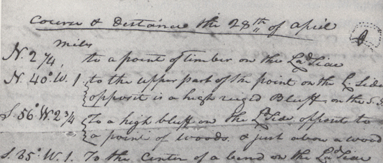
| Courses and distances 28th of April. [4] | miles | |
| North | to a point of timber on Lard. side | 2 ¼ |
| N. 40° W. | to a upper part of the point on Lard. opposite to a high rugged bluf |
1 |
| S. 56 W. | to a high bluff on the Lard. side just above a timbered bottom, and opposite a point of woodland on Stard. side |
2 ¾ |
| S. 85 W. | to the center of a bend on Lard. side. | 1 |
| N. 25 W. | to a point of timbered land on Lard. passing a point on Stard. side at 1 ¼ mes. |
3 |
| N. 18 W. | to the lower point of the timber in a bend on Stard. side | 2 |
| S. 4 W. | to a point of woodland on Stard. side. | 4 |
| S. 10 W. | to a high bluff point on Lard. side, the river making a considerable bend to S. E. |
2 |
| N. 80 W. | to a point of woodland on the Lard. side | 2 |
| N. 45 W. | to a high bluff point on the Stard. side. | 1 |
| S. 80 W. | to a point of woodland on Stard. side. | 3 |
| Miles | 24 |
[Clark]
a fine day river falling, wind favourable from the S. E. and moderate, I walked on Shore to view the Countrey, from the top of the high hills, I beheld a broken & open Countrey on both Sides, near the river Some verry handsom low plains, I killd. a Deer & a goose, Saw three black bear great numbers of Elk antelopes & 2 Gangues of Buffalow, the hills & Bluffs Shew the Straturs of Coal, and burnt appearances in many places, in and about them I could find no appearance of Pumice Stone, the wood land have a green appearance, the Plains do not look So green as below, The bottom are not So wide this afternoon as below Saw four bear this evening, one of the men Shot at one of them. The Antilopes are nearly red, on that part which is Subject to change i' e' the Sides & ⅔ of the back from the head, the other part as white as Snow, 2 Small runs fall in on the S. Side and one this evening on the Lard Side those runs head at a fiew miles in the hills and discharge but little water, the Bluffs in this part as also below Shew different Straturs of Coal or carbonated wood, and Coloured earth, such as dark brown, yellow a lightish brown, & a dark red &c.
| miles | Course & distance the 28th of April [5] | |
| N. | 2 ¼ | to a point of timber on the Lad Side |
| N. 40° W. | 1 | to the upper part of the point on the L. Side opposit is a high ruged Bluff on the S. S. |
| S. 56° W. | 2 ¾ | To a high bluff on the Ld Side opposit to a point of woods & just above a wood |
| S. 85° W. | 1 | To the center of a bend on the Lad Side |
| N. 25° W. | 3 | To a point of timbered land on the Ld. Side passing a point on the Std. Side at 1¼ miles |
| N. 18° W. | 2 | To the lower point of a timber in a bend to the Starboard Side. |
| S. 4° W. | 4 | To a point of wood Land on the Sd Side |
| S. 10° W. | 2 | to a high bluff point on the L. Side the river makeing a considerable bend S. E. |
| N. 80° W. | 2 | to a point of wood land on the Lard Side |
| N. 45° W. | 1 | to a high Bluff pt. on the Std Side |
| S. 80° W. | 3 | To a point of wood land on the Std Side |
| 24 |
[Ordway]
Sunday 28th April 1805. clear and pleasant. one of the Men caught a large beaver last night. we Set off eairly. the wind had Shifted to S. E. and blew gently So that we Sailed Some part of the time. proceeded on passed high bluffs on N. S. of a whiteish coulor rough hills and knobs on each Side. Some Smoth bottoms of cottonwood on each Side of the River. Saw large flocks of Cabberrie or antilope which is a Specie of the Goat kind, on the Sides of the hills on S. S. Saw Some dead on the edge of the river, which I Suppose the wolves had killed. Capt. Clark and our Intrepter walked on Shore on the S. S. we proceeded on untill abt. 3 oClock. came to where Capt. Clark had made a fire. we then halted to dine in a bottom above high bluffs on S. S. Capt Clark had killed one Deer & a goose. he Saw Several bair proceeded on towards evening we Saw a large black bair Swimming the River we went on Shore to head him in hopes to kill him. one man Shot & wounded it but it ran in to thick bushes So that we could not find it. Some of the party Saw Several more bair on the hills, on S. S. the bluffs make neare the river all this day and are verry Steep in some places & other places high & rough Some of which are White Stone and Clay, others are of a redish coulour, nearly like brick. we Camped [6] in a handsom bottom of c. w. timber on N. S. high steep bluffs on S. S. Came 24 miles this day.—
[Gass]
Sunday 28th. We set out early, had a fine day and went on very well. About 9 we halted for breakfast under very high bluffs on the North side. About 15 miles above the Yellow Stone river, the banks on the Missouri are not so high as below it, and the sand bars are more in the middle of the river. We came 24 miles and encamped [7] on the North side in a handsome bottom. The bottoms here are not so large, and have less timber on them than those below the Jaune.
[Whitehouse]
Sunday April 28th This day we had fine clear weather & pleasant, we set out Early in the morning; and proceeded on till 9 o'Clock A. M. when we stopped to break fast, under a high bluff lying on the South side of the River, about 15 Miles, above the Mouth of the River Roshjone, We found that the banks of the River Mesouri, was not so high, as it was lower down this River; and that the Sand barrs, lay generally in the middle of this River; The land as we passed along, appears to lay more level than what we had passed for several days past, but very Rich & fertile We encamped in the Evening, in a handsome bottom, on which there was Cotton wood Trees growing.— The bottoms are not so large in general here, as below, and the Timber not so plenty.— We came 24 Miles this day & the place we encamp'd on 〈lies〉 lay on the South side of the River Mesouri.—

