May 23, 1804
[Clark]
Wednesday May 23rd 8 Indians Kick: [Kickapoo] Came to Camp with meat we recved their pesents of 3 Deer & gave them Whisky:
Set out early run on a log: under water and Detained one hour proceeded on the Same Course of last night, (2 miles) passed the mouth of a creek on the Sbd. Side called Woman of Osage River [1] about 30 yds. over, abounding in fish, Stoped one hour where their was maney people assembled to See us, halted at an endented part of a Rock which juted over the water, Called by the french the tavern [2] which is a Cave 40 yds. long with the river 4 feet Deep & about 20 feet high, this is a place the India[ns; hole in paper] & french Pay omage to, many names are wrote up on the rock Mine among others, at one mile above this rock coms in a small Creek called Tavern Creek, [3] abov one other Small Creek, [4] camped at 6 oClock [5] (after expirencing great dificuselty in passing Some Drifts) [6] on the Stb Side, examined the mens arms found all in good order except the Detachment of Solds [soldiers] in the Perogue— R Field Killed a Deer.
ca. May 23, 1804, Field Notes, reverse of document 15
[Clark] [7]
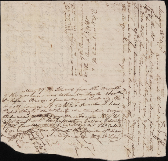
May 23rd Course of last night S: 75 W Contined 2 miles to the Said point St. Side passed the upper Point of the Island Thence S 52° W. 〈9〉 7 Miles to a pt. on St. Sd. passing Tavern Island two Small Isd. in a bend to the St: side the Mo: of Oge womans River at 1 m: the Cave Called the Tavern, Lbd Side at 5 [or 4?] m: Situated in the Clifts, opposit a Small Island on the Stbd Side (R. & Jo: Fields came in) with many people, passed the Tavern Cave, Capt Lewis' assended the hill which has peninsulis projecting in raged points to the river, and was near falling from a Peninsulia hard water all Day Saved himself by the assistance of his Knife, passed a Creek 15 yds. wide at 1 mile called Creek of the Tavern on the Lbd. Side, Camped opposit the pt. which the Last Course was to. one man Sick.
[Clark]
We Set out early ran on a Log and detained one hour, proceeded the Course of Last night 2 Miles to the mouth of a Creek on the Stbd. Side Called Osage Womans 〈Creek〉 R, about 30 yds. wide, opposit a large Island and a [NB: (american)] Settlement. [8] (on this Creek 30 or 40 famlys are Settled,[)] Crossed to the Settlemt. and took in R & Jo: Fields who had been Sent to purchase Corn & Butter &c. many people Came to See us, we passed a large Cave on the Lbd. Side 〈Called by the french the Tavern〉 [9] about 120 feet wide 40 feet Deep & 20 feet high many different immages are Painted on the Rock at this place. the Inds & French pay omage. many nams are wrote on the rock, Stoped about one mile above for Capt Lewis who had assended the Clifts which is 〈about〉 at the Said Cave 300 fee high, hanging over the Water, the water excessively Swift to day, we incamped below a Small Isld. in the Meadle of the river, Sent out two hunters, one Killed a Deer
| S. 75° W | 2 | mils to Osage Womn. R the Course of last Night |
| S. 52 W | 7 | mils. to a pt. on St. Side |
| 9 |
This evening we examined the arms and amunition found those mens arms in the perogue in bad order a fair evening Capt. Lewis near falling from the Pencelia of rocks 300 feet, he caught at 20 foot.
[Ordway]
Wendsday May the 23d 1804. we Set out at 6 oC. A. M. pleasant. passed the wife or faim of the Hoozaw River, 1 mile & half to we passed the Corn tavern a noted place on the S Side of the River, 120 feet long 40 abt. high & 20 perpenticular high clifts, 1 mile to Tavern Creek. encamped on S Side of the River. our arms & amunition Inspected,
[Floyd]
wensday may the 23d 1804 we Set out at 6 oclock Am plesent day passed the wife of Osoge River three miles and half we pased the tavern or Cave a noted place on the South Side of the River 120 Long 20 feet in Debth 40 feet purpendickler on the South Side of the River high Cliftes one mile to a 〈Crke〉 Creek Called tavern Creek and encamped on the South Side of the River our armes and amunition Inspected
[Gass]
Wednesday 23rd. At 6 o'clock in the morning we proceeded on our voyage with pleasant weather. Passed the mouth of the Osage [10] river on the south side, about a mile and an half below the Tavern Cave, a noted place among the French traders. One mile above this is the Tavern Creek. We encamped this evening on the south side of the river, and had our arms and ammunition inspected.
[Whitehouse]
Wednesday 23rd May 1804. [11] a fair morning. we Set out 6oClock A. m. and proceeded on verry well. passed Some Inhabitants called boons Settlement. passd. a noted [p]lace called cave tavern in a clift of rocks on South Side, which is 120 feet long 20 perpinticular high [illegible] us inspected our arms and camped.
Wednesday May 23rd We embarked this morning at 6oClock, having fair weather, and proceeded on very well, and passed some Plantations, which is called Boons settlement lying on the North side of the River. This settlement was made by Colonel Daniel Boone, the person who first discover'd Kentucky, & who was residing at this place, with a number of his family and friends.— [12]
Wednesday May 23rd A pleasant Morning & We proceed on our Voyage, and crossed the River to the So. side and passed by a noted place which is called Cave Tavern, which is in a Clift of Rocks, 120 feet long, and 20 feet perpendicular, laying on the South side of the River; In the evening our officers inspected our Arms and accoutrements.

