April 4, 1806
[Lewis]
This morning early we sent Sergt. Ordway in Surch of Sergt. Gass and party below the entrance of the Quicksand river from whom we have yet had no report. in the course of a few hours both parties returned. Sergt. Gass and party brought the flesh of a bear and some venison. they informed us that they had killed an Elk and six deer tho' the flesh of the greater part of those animals was so meagre that it was unfit for uce and they had therefore left in the woods. Collins who had killed the bear, found the bed of another in which there were three young ones; and requested to be permitted to return in order to waylay the bed and kill the female bear; we permitted him to do so; Sergt. Gass and Windsor returned with him. Several parties of the natives visit us today as usual both from above and below; those who came from above were moving with their families, and those from below appeared to be empeled mearly by curiossity to see us. About noon we dispatched Gibson Shannon Howard and Wiser in one of the light canoes, with orders to proceed up the Columbia to a large bottom on the South side about six miles above us [1] and to hunt untill our arrival. late in the evening Joseph Fields and Drewyer returned. they had killed two deer yesterday, and informed us that the meat would be dryed by midday tomorrow. we directed Drewyer and the two Feildses to ascend the river tomorrow to join Gibson and party, and hunt untill our arrival. this evening being fair I observed time and distance of ☽'s Eastern Limb from regulus with Sextant. ★ West.
| Time | Distance | Time | Distance | |||||
| h m s | h m s | |||||||
| P.M. | 8 50 41 | 73° 15' 0" | P.M. | 9 10 9 | 73° 27' —" | |||
| " 53 44 | " 16 45 | " 15 57 | " 30 — | |||||
| " 57 58 | " 19 15 | " 18 25 | " 32 15 | |||||
| 9 3 20 | " 23 15 | " 20 12 | " 32 45 | |||||
| " 6 49 | " 26 45 | " 22 — | " 33 15 |
Voorhis No. 3

[Clark]
Mouth of quick Sand River [2]
This morning early we Sent Sergt. Ordway in Serch of Sergt. Gass and party below the enterance of quick Sand river from whome we have yet had no report. in the Course of a fiew hours both parties returned. Sergt. Gass and party brought the Flesh of a Bear, and Some venison. they informed us they had killed an Elk and Six Deer tho' the flesh of the greater part of those Animals were So Meagre that it was unfit for uce, and they had therefore left it in the woods. Collins who had killed the bear, found the bead of another in which there was three young ones; and requested to be permited to return in order to waylay the bed and kill the female bear; we permited him to do So; Sergt. Gass and Windser returned with him. Several parties of the nativs visit us to day as usial both from above and below; those who came from above were moveing with their families, and those from below appeared to be impeled mearly by curiosity to See us. About noon we dispatched Gibson, Shannon, Howard & Wiser in one of the light Canoes, with orders to proceed up the Columbia to a large bottom on the South Side about Six Miles above us and there to hunt untill our arrival. late in the evening Jos Fields and Drewyer returned with a load of dried meat. they had killed two deer yesterday and informed us that the meat would be dryed by Mid-day tomorrow. We directed Drewyer and Field's to assend the river tomorrow and join Gibson & party, and hunt untill our arrival. this evening being fair observed time and distance of ☽'s Eastern Limb from regulus with Sextant ★ West [3]
[Ordway]
Friday 4th of April 1806. I and 2 men went over the River to see what success the hunters had met the hunters & returned with 5 of them they had killd. one Elk Six Deer and a handsome black bear & 2 Geese the hunters Soon went out again 4 [4] was Sent on with a Small Canoe a head 5 or 6 miles to a bottom on S. Side to hunt untill we come up. the after part of the day pleasant. one of the men killd. 2 deer. in the evening 2 of our hunters [5] came in had killd. 2 deer and caught a beaver
[Gass]
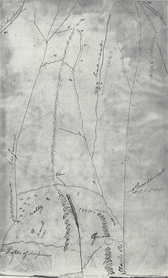
Friday 4th. After a cloudy morning, we turned out and killed a deer and some geese, and then went to the camp. [6] A party that went out on the upper side of Sandy river, killed 4 elk, and some of the men were out drying the meat.
While I was out hunting, Captain Clarke got information that a large river [7] came in on the south side of the Columbia, about 40 miles below this place, opposite a large island, [8] which had concealed it from our view; and went down with six men [9] to view it. He found it to be a very large river, 500 yards wide, with several nations of Indians [10] living on it; and its source supposed to be near the head waters of some of the rivers, which fall into the gulph of California. [11] On their return, they bought some dogs at an Indian village; and last night arrived at camp. Four men were sent on ahead this forenoon in a canoe to hunt; and I went out with two more [12] to the den where we saw the cubs, to watch for the old bear; we stayed there until dark and then encamped about a quarter of a mile off, [13] and went back early in the morning; but the old one was not returned: so we took the cubs and returned to camp.

