April 6, 1806
[Lewis]
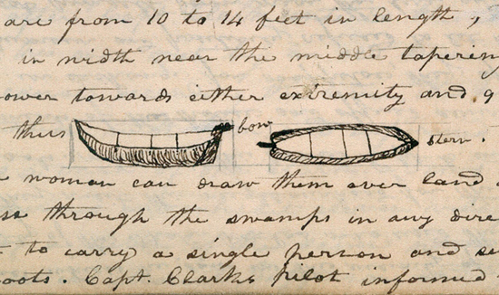
This morning we had the dryed meat secured in skins and the canoes loaded; we took breakfast and departed at 9 A. M. we continued up the N. side of the river nearly to the place at which we had encamped on the 3rd of Nov. [1] when we passed the river to the south side in quest of the hunters we had sent up yesterday and the day before. from the appearance of a rock near which we had encamped on the 3rd of November last I could judge better of the rise of the water than I could at any point below. I think the flood of this spring has been about 12 feet higher than it was at that time; the river is here about 1½ miles wide; it's general width from the beacon [NB: beaten before—but really beacon] rock [2] which may be esteemed the head of tide water, to the marshey islands is from one to 2 miles tho' in many places it is still wider. it is only in the fall of the year when the river is low that the tides are persceptable as high as the beacon rock. this remarkable rock which stands on the North shore of the river is unconnected with the hills and rises to the hight of seven hundred feet; it has some pine or reather fir timber on it's nothern side, the southern is a precipice of it's whole hight. it rises to a very sharp point and is visible for 20 miles below on the river. at the distance of ten miles from our encampment we met with our hunters in the upper end of the bottom to which we had directed them on the South side of the river. they had killed three Elk this morning and wounded two others so badly that they expected to get them. we therefore determined to encamp for the evening at this place in order to dry the meat, in surch of which we sent a party immediately and employed others in preparing scaffoalds and collecting firewood &c against their return. we found some indians with our hunters when we arrived; these people are constantly hanging about us.— As has been before mentioned Capt C set out with a party of seven men on 2ed inst. in surch of the entrance of the Multnomah river. he departed at ½ after 11 A. M and directed his course along the Southern side of the river. at the distance of 8 miles he passed the village of the Na-cha-co-lee tribe of the E-lute Nation; this village is not large and being situated on the main shore opposite to and S. of the Diamond Island it was concealed by that island from our view both ascending and decending the Columbia as we passed near the Northern shore. Capt C. passed this village without halting and continued his rout untill 3 P. M. when he arrived at a large double house of the Ne-er-cho-ki-oo tribe of the Shâh'-ha-la nation; at this place we had seen 24 additional straw and bark huts as we passed down last fall, the inhabitants of which as I have before mentioned reside at the great rapids of the Columbia river. about this place in different directions Capt C. saw a great number of small canoes lying scattered on the bank. these small canoes are employed by the women in collecting wappetoe; with one of these a woman enters a pond where the Sagitaria Sagittifolia grows frequently to her breast in water and by means of her toes and feet breakes the bulb of this plant loos from the parent radicle and disincumbering it from the mud it immediately rises to the surface of the water when she seizes it and throws it into her canoe which she always keeps convenient to her. they will remain in the water for hours together in surch of this bulb in middle of winter. those canoes are from 10 to 14 feet in length, from 18 to 23 inches in width near the middle tapering or becoming narrower towards either extremity and 9 inches deep their form is thus. [3] they are so light that a woman can draw them over land or take them with ease through the swamps in any direction, and are sufficient to carry a single person and several bushells of roots. Capt. Clarks pilot informed him that the small canoes which he saw in the vicinity of this lodge were the property of the Shah-ha-las who used them occasionally when they visit this neighbourhood for the purpose of collecting roots. while at this place Capt C. entered one of the appartments of the house and offered several articles to the natives in exchange for wappetoe, they appeared to be in an ill humour and positively refused to let him have any. Capt. C. sat himself down near the fire and having a part of a portfire match [4] in his pocket cut of a small peice of it and threw it in the fire; at the same time he took out his pocket compass and by means of a magnet which he had in the top of his inkstand he turned the nedle of the compass about very briskly; the match took fire and birned vehemently; the indians astonished and allarmed at these exhibitions, ran and brought several parcels of wappetoe and laid at his feet and begged that he would put out the bad fire; to this he consented; at this moment the match being exhausted was of course extenguished and he put up his compass & magnet. they were now much more complisant, tho' the women and children were yet so much allarmed that they took refuge in their beads and behing the men who were seting opposite to Capt. C. during the whole of this farcical seen an old man who was seting by continued to speak with great vehemence apparently imploring his god for protection. Capt. C. gave them on adiquate compensation for their roots and having lighted his pipe smoaked with the men. they appeared in a great measure to get the better of their allarm and he left them and continued his rout along the south side of Image canoe Island which he found to be three islands, the one in the center concealing the apperture between the two others in such manners that from the north side of the river where we have previously passed they all appeared to form one island only. at the distance of 13 miles below the village just mentioned, and at the lower point of what we have heretofore deemed the image canoe Island, Capt C. entered the Multnómâh river so called by the natives from a nation of that name who reside on wappetoe island a little below the entrance of this river. [5] Multnomah river discharges itself on the S. side of the Columbia 140 miles above the entrance of the latter into the Pacific Ocean, and may be justly esteemed one fourth of that noble river. Capt. C. found that this river had attained it's greatest annual hight and had now fallen about 18 inches. it has three small islands in it's mouth which conceal the river from the view of those who pass with the stream of the Columbia. from the Columbia at the entrance of the Multnomah river [NB: Cap C discovered] Mount Jefferson bears S. E. this is a noble mountain. I think equally as high as Mount St. Helines but it's distance being much greater than that of the latter, so great a portion of it dose not appear above the range of mountains which lie betwen boath those stupendious mountains and this point of view. like mount St. Heleans it's figure is a regular cone and is covered with eternal snow. M. St. Heleans from the same point boar N [blank], Mount Hood due East, and Mount Ranier nearly North. there is also a very high humped mountain a little to the East of Mount St. Heleans [6] which appears to lie in the same chain with those conic pointed mountains before mentioned. [NB?: all in full view of the mouth of Multnona ] soon after Capt Clark entered the Multnomah river he was met by an old Indian man alone in a canoe decending the river, the pilot had some conversation with him and informed Capt. C. that this was a man of the Clark-a'-mas nation who are numerous and inhabit eleven vilages on either side of a river of the same name which has it's source in Mount Jefferson and after tranversing a woody and fertile country discharges itself into the Multnomah river on it's E. side at the distance of about 40 miles from it's junction with the Columbia. the Clarkámas river is navigable for canoes a great distance, from the Indian account almost to the foot of mount Jefferson. the nation who inhabit it's borders live principally on fish with which this stream abounds and also on roots which they procure on it's borders. they sometimes also come down to the Multnomah and Columbia in surch of Wappatoe. they do not differ essentially in their language dress &c from the Quathlahpohtles and others in the vicinity of wappetoe island. The current of the Multnomah river is as gentle as that of the Columbia, glides smoothly with an even surface, and appears to possess sufficient debth for the largest ship. Capt. C. attempted to sound it with a cord of 5 fathoms which was the longest in his possession but could not find bottom at this debth for at least one third of the width of the river. Capt. C. ascended this river ten miles to a large wood house on the East side of the river, near which he encamped for the evening; the house being infested with such swarms of flees that they could not remain in it. this his guide informed him was the house of the Cush-hooks nation who reside just below the falls of the Multnomah river and who occasionally reside at this place for the purpose of collecting wappetoe. at present this house appeared to have been lately abandoned by the natives who had left therein exposed to every visiter various articles such as small canoes, mats, bladders of train oil, [7] baskets, bowls, and trenchers. this is a strong evidence of the honesty of the natives with rispect to the property of each other, but they have given us several evidences that they do not pay the same rispect to the property of white men. his guide further informed him that there were a number of small houses belonging to the last mentioned nation situated on two bayous which make out of the river a little above this large hose on the East side; that the inhabitants of these as well as those of the large house had gone up to the falls of the Multnomah river for the purpose of taking fish. these falls are situated at the distance of 2 days travel from the junction of the Multnomah and Columbia rivers agreeable to the Indian account which we have estimated at 60 miles or 20 m. above the entrance of Clarkámus river. Capt C. took the dementions of the hose of the Ne-mal-quin-ner [8] tribe of the Cushhooks nation near which he encamped on the 2ed inst. and found it presisely thirty feet by 40 squar constructed with broad boards and covered with the bark of the white cedar or arborvita; the floor is on a level with the surface of the earth and the internal arrangement is similar to those of the natives of the Sea coast.— these people carry on a trafic with the Killamucks of the coast across the mountains and by way of the Killamucks river. [9] from the Killamucks they obtain their train oil. The courses and distances taken by Capt. Clark in ascending the Multnomah river from it's junction with the Columbia river, commencing at the lower extremity of the Image canoe Islands are as follows. (viz) S. 30° W. 4 m. to the upper point of a small island in the center of Multnomah river. thence S 10° W. 3 m. to a sluce 80 yds. wideon Stard. which dividing wappetoe Island from the main land discharges itself into wappetoe inlet passed a willow point on Lard. S. 60° W. 3 ms. to a large indian house on the Lard. side, just below some high fir land the shore is bold and high on Stard. side. S 30° E. 2 ms. to the center of a bend under The highlands on Stard. side, passing a Lard point; from hence the river directed it's course to the E. of S. E. as far as Capt. C. could perceive it.— at this place the Multnomah river is 500 yds. wide and sufficiently deep to admit the largest ship. the river appears to be washing away it's banks in some places, and has more sandbars and willow points than the Columbia.— on the morning of the 3rd inst. Capt. Clark observed that the water had fallen in the course of the night about 5 inches. he set out early and proceeded up the river a short distance few miles and attempted a second time to fathom it but with the same success as before he could nt find bottom with his cord of 5 fathoms for the distance of half the width of the stream. Capt C. having fully satisfyed himself of the magnitude of this great river he set out on his return at 7 A. M. I have but little doubt but that this river waters a vast tract of country lying between the Western mountains and the mountainous country of the sea coast extending as far south as the waters of the gulph of Callifornia or about Latitude 37° North. at 11 A. M. Capt. C. arrived at the Ne-er-cho-ki-oo house where he had allarmed the inhabitants yesterday. he halted here a few minutes to smoke with these people who consisted of eight families. he found that his presents excited fresh allarm particularly among the women and children who hid themselves and took refuge behind the men as yesterday; the men held down their heads and seemed much conserned; he therefore remained in the house but a few minutes, returned to his canoe and pursued his rout. his pilot now informed him that these people as well as their relations at the falls of the Columbia were illy disposed bad men. soon after he set out he met five canoes on board of which there were as many families of the Shah-ha-la nation decending the river in surch of subsistence. they were extreemly anxious to come along side, but he forbid their doing so as their number was too considerable there being 21 men on board these canoes. his pilot told him that they were mischevous bad men. at 3 P. M. he arrived at the present residence of his pilot on the South side of the river opposite the Diamond Island. here he halted about an hour he found this house very large; it consisted of seven appartments in one range above ground each about 30 feet square. the entrances to these appartments were from passages which extended quite across the house, about 4 feet wide and formed like the walls of the hose of broad boards set on end extending from beneath the floor to the roof of the house. the apperture or hole through which they enter all those wooden houses are remarkably small not generally more than 3 feet high and about 22 inches wide. the ground plot of the Nechecolee house is thus [10] 1 1 1 1 the passages of 4 feet and 2 2 &c. the appartments of 30 feet square. this house is covered with the bark of the white cedar, laid on in a double course, supported by rafters and longitudinal round poles attatched to the rafters with cores of this bark. the peices of the cedar bark extend the whole length of the side of the roof and jut over at the eve about 18 inches. at the distance of 18 inches transverse splinters of dry fir is inserted through the cedar bark in order to keep it smooth and prevent it's edges from colapsing by the heat of the sun; in this manner the natives make a very secure light and lasting roof of this bark. in the vicinity of this house Capt. Clark observed the remains of five other large houses which appeared to have been sunk in the ground several feet and built after the method of those of the Elutes nation at the great narrows of the columbia with whom these people claim affinity. their language is the same with the Elutes, tho' in their habits, dress manners &c they differ but little from the Quathlahpohtles and others in this neighborhood. they make use of some words common to their neighbours but the air of their language is entirely different. they are much better formed and their men larger than the nations below. their women wear larger and longer robes which are made principally of deerskins dressed in the hair. they pay great rispect to their aged persons. Capt. C. observed several persons of both sexes who appeared to have arrived to great age yet they appeared perfectly healthy tho' most of them perfectly blind. [11] the loss of sight I have observed to be more common among all the nations inhabiting this river than among any people I ever observed. they have almost invariably soar eyes at all stages of life. the loss of an eye is very common among them; blindness in perdsons of middle age is by no means uncommon, and it is almost invariably a concommitant of old age. I know not to what cause to attribute this prevalent deficientcy of the eyes except it be their exposure to the reflection of the sun on the water to which they are constantly exposed in the occupation of fishing. Capt. C. enquired of the Nechcole the cause of the decline of their village. an old man who appeared to be of some note among them and the father of his guide brought forward a woman who was much marked with the small pox, and made signs that the inhabitants of those houses which he saw in ruins had all died with the disorder which marked the face of the woman and with which this woman was very near dying when a girl. from the apparent age of the woman Capt. C. supposed that it was about 28 or 30 years since this disorder had prevailed among these people. this is about the time which we have supposed that it prevailed among the Clatsops and others of the coast. Capt C. now prevailed on this old man to give him a sketch of the Multnomah river it's branches and the position and names of the Indian nations residing thereon this the old man son executed with his finger in the dust. (see scetch inserted on the 3rd inst.). [12] he informed that the Cush-hooks and Char-cow-ah nations who reside at the falls of that river were not numerous; but that the Cal-lâh-po-e-wah nation who inhabited both sides of this river above the falls as far as it was known to himself or his nation were very numerous. that the country they inhabited was level and wholy destitute of timber. that a high range of mountains passed the Multnomah river at the falls, on the upperside of which the country was one vast plain. the nations who inhabit this country reside on the rivers and subsist like those of the Columbia on fish and roots principally. Capt C. bought five dogs of these people and set out for my camp at 5 P. M. where he arrived a little before dark, on the evening of the third.— the party whom we sent for the flesh of the Elk which Shannon had killed returned in the evening with that of four, one had by some mistake been omitted. Drewyer and shannon found the two wounded Elk and had killed them. we set all hands at work to prepare the meat for the saffoald they continued their operations untill late at night. we directed Shannon to go out early in the morning with a party to bring in the Elk which had been left last evening in mistake. we also directed Drewyer and the two Feildses to ascend the river early in the morning to a small bottom a few miles above and hunt untill our arrival.—
[Clark]
Two Indians Came last night very late to our Camp and continued all night. early we had all the meat packed up and our Canoes loaded ready for to Set out and after an early brackfast at which time all things were ready and we Set out and proceeded to the Camp of Gibson & party about 9 miles, they had killed 3 Elk at no great distance and Wounded two others so badly that we expect to precure them. Sent a party of Six men with Shannon who had killed the Elk to bring in the Elk, and formed a Camp, near which we had a Scaffold made ready to dry the meat as Soon as it Should arive. Reubin Field killed a bird of the Quail kind or Class [13] which was whistleing near our Camp it is [lar]ger than the quail or partridge as they are Called Kentucky and [Virg]inia. it's form is presisely that of our partridge tho' its plumage differs in every part. the upper part of the head, Sides and back of the neck, including the Croop and about ⅓ of the under part of the body is of a bright dove coloured blue, under neath the under beak, as high as the lower edge of the eye, and back as far as the hinder part of the eyes and thence comeing down to a point in the front of the neck about ⅔rd of it's length downwards, is of a fine dark brick red. between this brick red and the dove colour there runs a narrow Stripe of pure white. the ears are covered with some coarse dark brown feathers. just at the base of the under chap there is a narrow transvirce Stripe of white. from the crown of the head two long round feathers extend backwards nearly in the direction of the beak and are of a black Colour. the length of these feathers is 2½ inches. one overlais and Conseals the other which is Somewhat Shorter and Seems to be raped in the plumage of that in front which folding backwards colapses behing and has a round appearance. the tail is composed of 12 dark brown feathers of nearly equal length. the large feathers of the wings are of a dark brown & are reather Short in purpotion to the body of the bird. in this respect very Similar to the partridge. the covert of the wings and back are of a dove Colour with a Slight admixture of redish brown. a wide Stripe which extends from Side to Side of the body and occupies the lower region of the breast is beautifully varigated with the brick red white & black which perdominates in the order they are mentioned and the Colours mark the feathers transversely. the legs are covered with feathers as low as the Knee; these feathers are of dark brown tiped with a dark brick red as are also those between and about the joining of the legs with the body. the foot is presisely that of the Common partridge except that they are as also the legs white. the upper beak is Short, wide at it's base, black, convex, curves downwards and reather obtusely pointed. it exceeds the under chap considerably which is of a white colour, also convex under neath and obtusely pointed. the nostrils are remarkably Small, placed far back and low down on the Sides of the beak. they are covered by a thin proterant elastic, black leather like Substance. the eyes are of a uniform pierceing black colour. this is a most butifull bird I preserved the Skin of this bird retaining the wings feet & head which I hope will give a just Idea of the bird. it's loud note it Single and Consists of a loud Squall, intirely different from the whistling of our partridge or quailes. it has a chiping note when allarmed like our partridge.— to day there was a Second of those birds killed which presisely resembles that just discribed. I believe those to be the mail bird the female, if so, I have not yet Seen.— [14]
at 6 P. M. Shannon and party returned with the flesh of five Elk. the two he had wounded in the morning he found dead near the place he had Shot them. we had the meat cut into thin pices and Scaffored with a fire under it to dry out, which we expect in the course of the night Can be effected. four Indians from the great rapids visited us to day and Continued all day. they give the Same account of the Scercity of provisions above the falls as has already been given by others. This Supply of Elk I think by useing economey and in addition of roots and dogs which we may probably precure from he Nativs on Lewis's river will be Sufficient to last us to the Chopunnish where we Shall Meet with our horses—. and near which place there is Some deer to be precured.
Frazer killed a pheasent of the Common kind. Jos: Field killed a vulture of that Speces already discribed. [15] in the evening late the Indians left us and returned to their village. we derected that fires be kept under the meat all night. and tha Drewyer and the two Fields proceed on to the next bottom and hunt untill we Should arive. 9 miles
[Ordway]
Sunday 6th of April 1806. a clear pleasant morning. we loaded up and Set out proceeded on verry well about 8 miles and halted at the Camp of our hunters they having killed 3 Elk in a bottom S Side 8 men went out for the meat Ruben Fields killed a curious handsom bird [16] which made a curious noise it had blue feathers on its breast and under its throat and 2 long feathers on the top of its head the longest 3 Inches long & a handsome Small bird. he Skined it and it is taken care of to carry home with us. in the evening the men returned with the meat of 5 Elk having found 2 more than they expected which the hunters had killed. So we Camped [17] here for the night in a Small willow bottom near high river hills on South Side eat & fleased the greater part of of the Elk meat to dry &C.
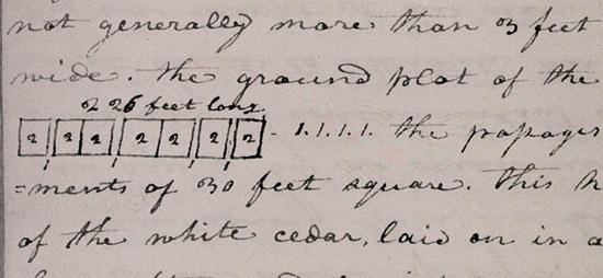
[Gass]
Sunday 6th. We had a fine morning, with some fog; about 10 o'clock we set out; passed a beautiful pairie on the north side, which we could not see for the fog as we went down; proceeded on about 9 miles and came to our hunters' camp. [18] they had killed 5 elk; so we halted, sent out for the meat and began to dry it. We are now at the head of the Columbia valley; which is a fine valley about 70 miles long, abounding with roots of different kinds, which the natives use for food, especially the Wapto roots which they gather out of the ponds. The timber is mostly of the fir [19] kind, with some cherry, [20] dog-wood, [21] soft maple [22] and ash; [23] and a variety of shrubs which bear fruit of a fine flavour, that the natives make use of for food.

