November 2, 1805
[Clark]
1805–March 22, 1806
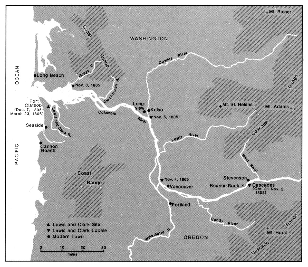
Meridian altitude 59° 45' 45" made a portage of about 1½ miles with half of the Baggage, and run the rapid with the Canoes without much damage, [2] one Struck a role & Split a little, and 3 others took in Some water 7 Squars Came over the portage loaded with Dried fish & Beargrass, [3] Soon after 4 men Came down in a Canoe after takeing brackfast, & after taking a meridian altitude we Set out Passed 2 bad rapids one at 2 & the other at 4 mile below the Isd on Lard. and upper end of Strawberry Island [4] on the Stard. Side from the Creek end of last Course
| S. 50° W. | 5 | miles to a timbered bottom on the Lard. Side, passed the Lowr. point of Strawbery Isd. at 3 miles, a Isd Covd with wood below on Stard. Side a remarkable high rock on Stard. Side about 800 feet high & 400 yds round, the Beaten Rock. [5] The mountains and bottoms thickly timbered with Pine Spruce Cotton and a kind of maple Passed 2 Small wooded Islands on Std. Side, 〈opsd〉 below the lower Island on the Stard. Side at 4 miles an Indian village of 9 Houses. The river wider and bottoms more extencive. |
| S. 47° W. | 12 | miles to a 〈Lard.〉 Stard. point of rocks of a high clift of black rocks. [6] passed a Stard. Point at 4 miles. here the moun- tains are low on each Side & thickly timbered with pine. river about 2 miles wide, passed a rock at 10 miles in the middle of the river this rock is 100 feet high & 80 feet Diameter, a deep bend to the Stard. Side, |
We Labiech killed 14 Geese & a Brant, Collins one Jos. Fields & R 3 those gees are much Smaller than Common, and have white under their rumps & 〈abov〉 around the tale, [7] The tide rises here a fiew 9 Inches, I cannot assertain the prosise hite it rises at the last rapid or at this place—of Camp. [8]
The Indians we left at the portage passed us this evening one other Canoe Come up
| S. 58° W. | 4 | miles 〈to a〉 Stard. point of a large bottom. Encamped on the 21 Lard Side river about 2 miles wid Country thickly tim- bered we Encamped behind a large rock in the Lard. Bend, a Canoe with 7 Inds. came down & Encamped with us |
| 21 |
[Clark]
Examined the rapid below us more pertcelarly the danger appearing too great to Hazzard our Canoes loaded, dispatched all the men who could not Swim with loads to the end of the portage below, I also walked to the end of the portage with the carriers where I delayed untill everry articles was brought over and canoes arrived Safe. here we brackfast and took a Meridn. altitude 59° 45' 45" about the time we were Setting out 7 Squars came over loaded with Dried fish, and bear grass neetly bundled up, Soon after 4 Indian men came down over the rapid in a large canoe. passed a rapid at 2 miles & 1 at 4 miles opposite the lower point of a high Island on the Lard Side, and a little below 4 Houses on the Stard. Bank, [10] a Small Creek on the Lard Side opposit Straw berry Island, which heads below the last rapid, opposit the lower point of this Island passed three Islands covered with tall timber opposit the Beatin rock Those Islands are nearest the Starboard Side, imediately below on the Stard. Side passed a village of nine houses, [11] which is Situated between 2 Small Creeks, and are of the Same construction of those above; here the river widens to near a mile, and the bottoms are more extensive and thickly timbered, as also the high mountains on each Side, with Pine, Spruce pine, Cotton wood, a Species of ash, and alder. at 17 miles passed a rock near the middle of the river, about 100 feet high and 80 feet Diamuter, [12] proceed on down a Smoth gentle Stream of about 2 miles wide, in which the tide has its effect as high as the Beaten rock or the Last rapids at Strawberry Island,— Saw great numbers of waterfowl of Different kinds, Such as Swan, Geese, white & grey brants, [13] ducks of various kinds, Guls, & Pleaver. Labeach killed 14 brant Joseph Fields 3 & Collins one. we encamped under a high projecting rock on the Lard. Side, [14] here the mountains leave the river on each Side, which from the great Shute to this place is high and rugid; thickly Covered with timber principalley of the Pine Species. The bottoms below appear extensive and thickly Covered with wood. river here about 2½ miles wide. Seven Indians in a Canoe on their way down to trade with the nativs below, encamp with us, those we left at the portage passed us this evening and proceeded on down The ebb tide rose here about 9 Inches, the flood tide must rise here much higher— we made 29 miles to day from the Great Shute—
[Ordway]
Saturday 2nd Nov. 1805. a fair morning. we carried Some of our baggage past the last rapid about one mile further and took one canoe down at a time partly loaded. about 10 oClock A. M. we got all Safe below the last bad rapid we can git any account of from the natives. then loaded up the canoes. 2 Indians came to us from a village below who had red and blue cloath blankets which appeared new one had a brass musket and powder flask a little powder &C. about 12 we Set out passed a large Island mostly prarie which our officers name Strabery Island. we halted a fiew minutes and killed Several geese. passd. Several old villages about or a little below the of the big Shoote on the Stard. Side. at the foot of Said Island we passd. over a rapid which high waves in it the hills high on each Side but mostly covred with pine timber. proceeded on about 4 miles further the River got more Smooth the current gentle wide and Strait. passed the mo. of a creek [15] on the Lard. side Saw a number of Spring runs flowing from the high clifts and Mountains. Some of which falls off about 100 feet perpinticular [16] we came 21 miles this day & Camped [17] under a verry Shelving clift on the Lard. Side—
[Gass]
Saturday 2nd. There is here a small rapid below the falls, where the men had to carry part of the baggage across a portage of two miles and an half, while the rest took down the canoes. At 12 o'clock we proceeded on again; passed a narrow rapid part of the river of about 8 miles, the hills on both sides are very high, and a number of fine springs flowing out of them, some of which fall 200 feet perpendicular. The hills are mostly solid rock. On our way we passed two Indian lodges. At the end of eight miles, the river opens to the breadth of a mile, with a gentle current. We came 23 miles, and encamped at a high peak resembling a tower of the south side. The country here becomes level, and the river broader. One of the Indian canoes remained with us and the other three went on. On our way and at camp we killed 17 geese and brants. [18]
[Whitehouse]
Saturday 2nd Nov. 1805. a clear morning. we carried a part of the baggage below the other last rapids one mile further and ran over one canoe down the rapid at a time. about 10 oClock A. m. we got all below the last rapids we have any acct. of from the Savages, then loaded the canoes agn. and about 12 oC Set out and proceeded on over Several more rapids at the foot of large Islands. Saw 2 old ancient villages below the big rapids which was evacuated, the bark taken off of one of them and put in a pond to Soak. the frames verry large. the mountains verry high on the Lard. Side and on the S. Side a little back from the River. proceed. on abt. 4 miles then the Riv. got Smooth the current verry gentle &c the River wide and Strait the remdr. of the day we passed a creek on L. Side &c. great nomber of Spring runs, and Springs flowing from the high clifts and mountains and fell off down 100 feet or more. high clifts on each Side. the Indians over took us with their canoes, which they carryed past the big rapids Saw 2 Indians dressed in red Scarlet and one in blue cloth which appeared new. they had a Musket which was made all of brass and copper, a powder flask &c. towards evening the River got more wide could Scarsely perceive any current at all. the mont. and clifts cont. all day. went 21 miles and Camped under a Shelving clift & a green on the Lard. Side. Saw this day abundance of geese and killed 16 of them. Saw Some Swan and brants ducks &c. passd. one village this after noon on the S. Side. passd. Some narrow bottoms high towers of rocks &c. the country is timbred but mostly Spruce and Pine. Some oak &c;—
Saturday Novemr. 2nd A Clear morning but cool. Our party were all engaged in carrying a part of our baggage &ca below these rapids, to a place below the last part of them. On our party returning; they carried the whole of our Canoes down the last Rapid one at a time. About 10 o'Clock A. M. we got them all safe below it. This Rapid is the last, that we have any account of, that lays on the Columbia river, from the Indians. We loaded our Canoes & about 12 o'Clock A. M. We proceeded on down the Columbia River, & passed over several small rapids which lay at the foot of an Island. We saw lying below the big Rapid this day, 2 old ancient looking Indian Villages, which were without any Inhabitants. The bark had been taken off one of those huts in this Village & put into a pond to Soak.— The frames of these huts were very large.— We saw large high Mountains which lay on both sides of the River, a small distance back from it.—
We proceeded on about 4 Miles when the River that had been running rapid this day & rough, became quite smooth & gentle. The River at this place is wide & strait, & remained so during the whole of this day. We passed a creek which lay on the So. side of the River, & a great number of springs & Spring runs flowing from the Clifts & mountains which lay high & fell from off these Clifts & Mountains upwards of 100 feet into the River. The high Clifts & rocks lies on both sides of the River. The Indians that we had left at the 〈east〉 first fall (or rapid) overtook us with their Canoes, which they had carried below the big rapid. We saw on board those Indians Canoes 2 of the Indian Men, who were dressed in Scarlet & one of them dressed in blue Cloth all of which appeared to be new. Those Indians had a Musket which the Stock was made of Brass & Copper & a Powder flask.— Towards evening the River got rather wide, & we could scarcely perceive any current running in the River. The Clifts and mountains continued back a small distance from the River all this day. We passed in the afternoon an Indian Village which lay on the South side of the River. We also passed some high towers of Rocks & Narrow bottoms of land which lay along the River on both sides of it. The Country this day is Timbered land, the growth Spruce, Pine & some Oaks; & the soil very poor. We saw this day in the River, Geese, Swans, Brants & ducks.— Some of our party shot 16 Geese, which we got. We came 21 Miles this day, & encamped under a shelving rock lying on the South side of the River, Our course Continuing West.—

