November 1, 1805
[Clark]
a verry cold morning wind from N. E and hard
| h | m | s | h | m | s | |||
| A. M. | 9 | 22 | 51 | P M | 3 | 12 | 21 | |
| " | 25 | 6 | " | 14 | 38 | |||
| " | 27 | 24 | " | 16 | 47 |
altitude produced 36° 22' 15"
Set all hands packing the loading over th portage which is below the Grand Shutes and is 940 yards of bad way over rocks & on Slipery hill Sides The Indians who came down in 2 Canoes last night packed their fish over a portage of 2½ miles to avoid a 2d Shute. four of them took their canoes over the 1st portage and run the 2d Shute, Great numbers of Sea otters, [1] they are So Cautious that I with deficuelty got a Shute at one to day, which I must have killed but Could not get him as he Sunk
Lattitude: 45° 44' 3" North—
Cronomiter is 3 m 27 s too slow m. Time
1st Novr. P M
Observed time and distance of the moons western Limb from Antares ★ West—
| Time | Distance | ||
| h m s | |||
| P. M. | 7 5 33 | 91° 50' 45" | |
| " 8 25 | " 51 15 | ||
| " 10 53 | " 52 00 | ||
| " 17 1 | " 52 30 | ||
| " 18 59 | " 52 30 |
The mountains is so high that no further observations can be made with this ★ observed time and distance of Moon's Western Limb from α Areitis ★ East
| Time | distance | ||
| h m s | |||
| P M. | 7 29 34 | 58° 4' 30" | |
| " 33 12 | " 4 | ||
| " 35 21 | " 3 15 | ||
| " 37 16 | " 2 | ||
| " 39 2 | " 1 | ||
| " 40 35 | " 0 15 |
We got all our Canoes and baggage below the Great Shute [2] 3 of the canoes being Leakey from injures recved in hauling them over the rocks, obliged us to delay to have them repaired a bad rapid just below us three Indian canoes loaded with pounded fish for the &c. trade down the river arrived at the upper end of the portage this evening. I Can't lern whether those Indians trade with white people or Inds. below for the Beeds & copper, which they are So fond of— They are nearly necked, prefuring beeds to anything— Those Beeds they trafick with Indians Still higher up this river for Skins robes &c. &c. The Indians on those waters do not appear to be Sickly, Sore eyes are Common and maney have lost their eyes, Some one and, maney both, they have bad teeth, and the greater perpotion of them have worn their teeth down, maney into the gums, They are rather Small high Cheeks, women Small and homely, maney of them had Sweled legs, large about the knees,—owing to the position in which they Set on their hams, They are nearly necked only a piece of leather tied about their breech and a Small robe which generally comes to a little below their wastes and Scercely Sufficely large to cover arround them when confined— [3] they are all fond of Clothes but more So of Beeds perticularly blue & white beeds. They are durty in the extreme both in their Coockery and in their houses.
Those at the last Village raise the beads [beds] about five feet from the earth—under which they Store their Provisions— Their houses is about 33 feet to 50 feet Square, the dore of which is about 30 Inc. high and 16 Inches wide in this form [4] cut in a wide pine board they have maney imeges Cut in wood, generally, in the figure of a man— Those people are high with what they have to Sell, and Say the white people below Give them great Prices for what they Sell to them. Their nose are all Pierced, and the wear a white Shell maney of which are 2 Inch long pushed thro the nose— all the women 〈are〉 have flat heads pressed to almost a point at top The press the female childrens heads between 2 bords when young—untill they form the Skul as they wish it which is generally verry flat. This amongst those people is considered as a great mark of buty— and is practised in all the tribes we have passed on this river more or less. men take more of the drugery off the women than is common with Indians—

| E-neé-Shur at the falls |
| E-chee-lute at the lower whorl |
| Che-luck-it-te-guar below |
| Chim-ná-pum Nation above |
| qua-Ca-ha— near |
[Clark]
A verry Cool morning wind hard from the N. E. The Indians who arrived last evining took their Canoes on ther Sholders and Carried them below the Great Shute, we Set about takeing our Small Canoe and all the baggage by land 940 yards of bad Slippery and rockey way The Indians we discoverd took ther loading the whole length of the portage 2½ miles, to avoid a Second Shute which appears verry bad to pass, and thro' which they passed with their empty canoes. Great numbers of Sea Otters, they are So cautious that I with dificuelty got a Shot at one to day, which I must have killed, but could not get him as he Sunk
we got all our baggage over the Portage of 940 yards, after which we got the 4 large Canoes over by Slipping them over the rocks on poles placed across from one rock to another, and at Some places along partial Streams of the river. in passing those canoes over the rocks &c. three of them recived injuries which obliged us to delay to have them repared.
and Oregon, October 30–November 2, 1805, Codex H, p. 4

and Oregon, October 30–November 2, 1805, Codex H, p. 4
Several Indian Canoes arrived at the head of the portage, Some of the men accompanied by those from the village came down to Smoke with us, they appear to Speak the Same language with a little different axcent [6]
I visited the Indian 〈Lodge〉 Village found that the Construction of the houses Similar to those abov described, with this difference only that they are larger Say from 35 to 50 feet by 30 feet, raised about 5 feet above the earth, and nearly as much below The Dores in the Same form and Size cut in the wide post which Supports one end of the ridge pole and which is carved and painted with different figures & Hieroglyphics Those people gave me to eate nuts berries & a little dried fish, and Sold me a hat of ther own taste without a brim, and baskets in which they hold their water— Their beads are raised about 4 ½ feet, under which they Store away their dried fish, between the part on which they lie and the back wall they Store away their roots burries nuts and valuable articles on mats, which are Spread also around the fire place which is Sunk about one foot lower than the bottom flore of the house, this fire place is about 8 feet long and Six feet wide Secured with a fraim those houses are calculated for 4, 5 & 6 families, each familey haveing a nice painted ladder to assend up to their beads. I Saw in those houses Several wooden Images all cut in imitation of men, but differently fasioned and placed in the most conspicious parts of the houses, probably as an orniment I cannot lern certainly as to the traffick those Inds. carry on below, if white people or the indians who trade with the Whites who are either Settled or visit the mouth of this river. I believe mostly with the latter as their knowledge of the white people appears to be verry imperfect, and the articles which they appear to trade mostly i e' Pounded fish, Beargrass, and roots; cannot be an object of comerce with furin merchants— however they git in return for those articles Blue and white beeds copper Tea Kittles, brass arm bands, some Scarlet and blue robes and a fiew articles of old clothes, they prefer beeds to any thing and will part with the last mouthfull or articles of clothing they have for a fiew of those beeds, those beeds the trafick with Indians Still higher up this river for roabs, Skins, cha-pel-el bread, [7] beargrass &c. who in their turn trafick with those under the rockey mountains for Beargrass, 〈guarmash〉 Pashico roots & robes &c.
The nativs of the waters of the Columbia appear helthy, Some have tumers on different parts of their bodies, and Sore and weak Eyes are common, maney have lost their Sight entirely great numbers with one eye out and frequently the other verry weak; This misfortune I must again asscribe to the water &c. They have bad teeth, which is not common with indians, maney have worn their teeth down and Some quite into their gums, this I cannot Satisfactorily account for it, do ascribe it in some measure to their method of eateing, their food, roots pertiularly, which they make use of as they are taken out of the earth frequently nearly covered with Sand, I have not Seen any of their long roots offered for Sale clear of Sand. [8] They are rether below the Common Size high cheeks womin Small and homely, and have Swelled legs and thighs, and their knees remarkably large which I ascribe to the method in which they Sit on their hams—go nearly necked wareing only a piece of leather tied about their breast which falls down nearly as low as the waste, a Small roabe about 3 feet Square, and a piece of leather tied about their breach, They [X: womin] have all flat heads in this quarter 〈both men and women,〉 They are tirty in the extream, both in their person and cooking, ware their hare loose hanging in every direction. They asc high prices for what they Sell and Say that the white people below give great prices for every thing &c.
The noses are all pierced and when they are dressed they have a long tapered piece of white shell or wampum 〈pushed〉 put through the nose. Those Shells are about 2 inches in length. I observed in maney of the villeages which I have passed, the heads of the female children in the press for the purpose of compressing their heads in their infancy into a certain form, between two boards [9]
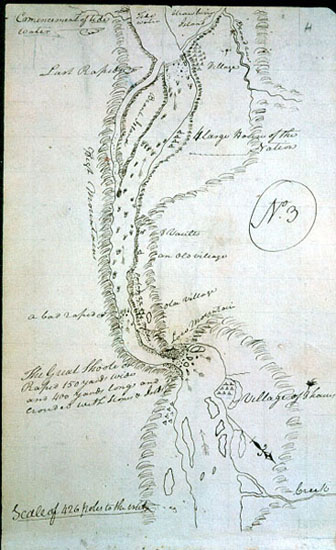
from the Lewis's River in Latd. 46° 15' 13 9/10" N.
to the Great Pacific Ocian—estimated [10]
| miles | 18th October 1805. | |
| S 55° E | 12 | To a bend on the Lard side opposite a verry bad rapid opposit to a lower point of a large Island on the Stard. Side & Several Small Islds. in the river. passed a Island in the mouth of the Ki moo e nim. one in the middle of the river 3 miles long at 8 miles; and one a little below on which was 9 mat Lodges of Indians drying fish 2 Lodges on Std. at the rapid. |
| S 20° E | 2 ½ | Miles to 2 Lodges of Indians on a Small Island near the Stard. point. |
| S 45° E | 1 ½ | Miles to the mouth of a Brook under a high hill on the Lard. Side, here the river enters a high range of hills about 200 feet rugid black rocks makeing out into the river from each Side. |
| S. 12° W. [11] | 4 | Miles to a point of rocks in a Lard. Bend passed 2 Small Islands one on each side and one in the middle at 2 miles at the uppr. point 2 Lodges of Indians drying fish opsd. a rapid, passed 9 Lodges of Indians drying fish on an Island Close under the Stard. Side, one mile lower 5 Lodges of Indians drying fish on the Same Is- land. 〈no bottom〉 Encamped on the Lard Side |
| 19th of October 1805. | ||
| S. 45° W. | 14 | Miles to a rock on the Lard. Shore resembling a hat at a rapid at the lower point of an Island in the middle of the river on which there is 7 Lodges of nativs drying fish, and opposit the head of an Isld. near the Std. side on which is 5 Lodges of nativs drying fish at 8 miles passed an Island close to the Lard Shore 6 miles long op- posit the Lower point of this long Island is a Smal Island on which is 5 Lodies deserted at present. passed a Stard point at 4 miles. |
| S 80° W. | 7 | miles to a point of rocks in a Stard. Bend passed the Island near the Stard. Side at 1 mile (passed a verry bad rapid) above the Expiration of the Course passed rapid 2 miles long with Sevl. Small Islands in it low lands on Lard Side, See 2 mountains S W. & W. Covered with Snow. This rapid has large banks of Muscle Shells. |
| S 70° W. | 12 | Miles to a Small Island on the Lard Side at some willows passed 20 Lodges of Indians drying fish Scattered on the Stard. Bank in a vally. haveing passed the high Countrey on the Stard. at ½ a mile. passed a Small rapid at 11 miles. |
| S. 45° W. | 3 | Miles to Some willow trees below an Island close under the Lard. Side, opposit to 24 Lodges of nativs drying fish on the Stard. Side and on a Small Island in the middle of the river. Countrey low on each Side. This nation above was much allarmed at our approach. we encamped on the Lard. Side. |
| 56 | ||
| 20th October 1805 | ||
| West | 6 | Miles to a Stard. bend at the head of a rapid passed 3 Indian Lodges on Lard. deserted. |
| S. 20° W. | 10 | Miles to a Lard. bend opposit a large Island on the Stard. Side passed rocky bad rapid with a chain of rocks from the Stard Side, & Several Small Islands near the Lard. side Great number of Pelicans at this rapid and black comerant 4 Lodges of Indians fishing on an Island close to the Stard. Side. |
| S 60° W. | 8 | Miles to the Comencement of a high land on the Stard. Side. passed 3 Islands nearly opposit to each other 2 on the Stard. large one on the Lard Small 17 Lodges of Indians fishing on those 3 Islands, a vault at the upper point of the 1st. Island. passed a bad rapid at the lower point of a Small Island at 7½ miles on which 4 Lodges of nativs drying fish. |
| S. 45° W. | 18 | Miles to a point of highland in the Std. bend passed a large Island in the middle of the river at 8 miles below which we passed a Lard. point 5 Small Islands on the lard. and 5 on the Stard. Sides, and one Small one in the middle of the river at 16 miles. passed a Small rapid. |
| 42 | ||
| 21st October 1805 | ||
| South | 3 | Miles to a Larboard bend of high land. |
| S. 55° W. | 17 | Miles to a Lard Bend below a rapid and high ruged rocks. passed a Small Island at 2½ miles; one at 4 miles in the middle of the river below Some Swift water 8 Lodges of Indians on the Stard Side drying fish. (we Brackfast &c.) passed a rapid at 10 miles below a Stard pt. 2 Lodges on Std. passed 5 Lodges of nativs drying fish on the Stard Side above the lower rapid, opsd. Som rocks out in the river from both sides. |
| N. 45° W. | 4 | Miles to a Stard. Bend passing the lower point of an Is- land at 1 mile 2 Lodges of nativs on the Stard Shore dry- ing fish. the rocks on the Lard. appear to have Sliped into the river from the Clifts— at 2 miles passed a very bad rockey rapid dificuelt and Crooked, eminc rocks in it 2 Lodges of nativs below on the Stard. Side. Some fiew low pine on the tops of the hills. |
| S 60° W. river ☞ |
5 | Miles to be the Stard. Bend passed many rugid black rocks in different parts of the river. a bad rapid at 2 miles, the river narrow at the expiration of this course a river falls in on the Lard Side R de page 40 yards wide. Islands of rocks in every direction |
| S. 52° W. | 13 | Miles to the upper point of a rock Isld. 80 feet high at a rapid passed the little river rapid and through narrow Chanels between hugh large rocks. 4 Lodges of Inds. on Stard. Side opposit (Encamped at) 5 Lodges of In- dians below a Small Island four miles below the little river [12] at 10 miles passed rapid large rocks nearly across the river. 6 Lodges of Indians drying fish on the Std. Side at 12 miles passed a bad rapid. 5 Lodges of nativs on Std. 20 Stacks of fish and Inds. gigging |
| 22nd October 1805 | ||
| S. 30° W. | 3 | Miles to the Mouth of
To war ne hi ooks
[13] River in a Lard Bend 200 yards wide and very rapid and contains a great qty of water rapid ¼ of a mile up this river which is three long 3 Sand Islands in the mouth of this river |
| 144 | Miles From Lewis's river [14] | |
| West | 4 | Miles to a bend on the Stard Side passed the rock Is- land at 2 miles 8 Lodges on its Lower point, at 3 miles 10 Lodges on the Stard. Main Shore at the end of this course is 6 Lodges of nativs opposit is the lower point of a large Island near the Lard Side from the mouth of [blank] |
| S. 45° W. | 2 | Miles to a point of Sand on the Stard. side opposit to the center of the great Falls passed 17 Lodges scattered on The Stard Bank (Portage of 1200 yards on the Stard Side over rock & sand) |
| Falls | 6 | Miles from Clarks River |
| 24th October 1805 | ||
| West | 2 | Miles passing a Lard. Point of Sand, and a Stard. point. 3 lodges above a Deep bend to the Stard. to a point of high rocks at the enterance of a narrow Chanel. Lodges on the Stard Side at the foot of the rock |
| S. 70° W. | 2 | Miles to a rock Island in the middle of the river at a bad rapid, passed through the little narrows ¼ of a mile long & 45 yards wide, bad whorly boils & Sucks. a Lodge be- low where the river widens to about 200 yds |
| S. 50° W. | 2 | Miles to a high rugid rock at the mouth of the Great nar- rows a Deep bend to the Stard. Side on which is a village of 21 worm comfortable houes Passed a large rock in the middle of the river |
| Grt. Narrows | 6 | Miles from the Great Falls |
| 25th October 1805 | ||
| S. 34° W. | 3 | Miles through a Narrow Swift bad Chanel from 50 to 100 yards in width, one verry bad place in this Chanel at ½ mile maney bad whorls and Sucks, a rock which Sepe- rates The Chanel at 2½ miles the Current running aginst the upper point, to the enterance of a Deep bend to the Stard. Side (made a portage of ½ a mile below the 1st bad place in the Chanel) one of the Canoes filled, and afterwards run against a rock in the Chanel. |
| S. 20° W. | 2 | Miles to a high rock on the Lard Side passed through a narrow Chanel on The Stard. of a large rock which di- vides the Chanel at 1 mile. (Saw a Chief) |
| N. 60° W. | 1 | Mile to a high rock in a Stard. Bend passed a Deep bason on the Lard Side and between rugid rocks. Still water |
| S. 60° W. | 4 | Miles to the mouth of a large Creek in the Lard Bend, a high point of rocks (on which we Camped) and near Some Timbered bottom of white oake and pine river ½ a mile wide and Current jintle. |
| 10 | ||
| 28th October 1805 | ||
| N. 50° W. | 2 | Miles to a nitch in the Lard. Bend a Clift of rocks on each Side about 90 feet high on which there is Some fiew pine. |
| N. 10° W. | 2 | Miles to the
Chel-luck-it-te-quar
Village of Eight houes on the Stard Side under Some high rocks, a Small Creek falls in on the Lard Side. |
| North | 1 | Mile to a rock island on the Stard Side opposit to which the wind obliged us to come to the Lard. side is a nitch above a point of high rocks where we Stayed all night. rained &c. &c. |
| 29th October 1805 | ||
| N. 55° W. | 4 | Miles to a Lard point passed a Brook on Lard. |
|
West Cataract river ☞ |
8 | Miles to a rock Island near the middle of the river at 1 mile is a friendly Village of 7 houses of the Chil luck it te quar Nation and the residance of their great Chief— at 5 miles passed the mouth of a River which we call Cata- ract river 60 yards wide on the Std. side below the mouth of which is a Village of 11 houses of the Chil luck it te quar nation |
| S. 60° W. | 5 | Miles to a rock Island in a Lard Bend, passd. 2 rocks in the river passed 2 houses on the Std. side at 1 mile; and 2 houses at 4 miles on the Stard. Side. |
| S. 80° W. river ☞ |
6 | Miles to 4 houses in a point of Timber bottom on the lard. Side above the enterance of a 〈large〉 river 40 yard wide we call river La biache a bottom on the Stard. Side in which there is scattered on the bank 14 Houses of Indians (The falls mountain covered with Snow is South) |
| S. 70° W. | 6 | Miles to a high clift of rocks in a in Stard. bend passing a large Sand bar from the Lard. for 4 miles. a large Creek 28 yards wide at 1 mile I call Canoe Creek, a butifull Spring below. A Small Stream fall over rocks of 100 feet Lard Side. at 5 miles passed 4 Indian Houses in a bottom on the Lard Side. |
| S. 56° W. | 6 | Miles to a point of a timbered bottom on the lard. Side. passed a Stard. point at 2 miles, here the mountains are high and those on the Lard. has Snow on them. at 3 miles is 3 houses of Indians on the Star Side (where we Encamped) |
| 30th of October 1805 | ||
| S 70° W. | 3 | Miles to a point of rocks on the Stard. Side passed a number of Stumps at Some distance in the water cur- rent Still 1 mile pr. hour |
| S. 74° W. | 2 | Miles to a point of a timbered bottom on the Stard. Side. Stumps & rocks out in the water |
| West river ☞ |
4 | Mile to the mouth of a river on the Std. side about 60 yards wide maney large rocks promiscuisly in the river both above and below a large Sand bar in the middle of the river. This river we Call Cruzats River. [15] |
| S. 45° W. | 2 | Miles to a large rock in the river passed Several rocks and a large Sand bar out in the river. High mountains on each side rough and covered with a very thick groth of Pine Cedar Cotton & Oake |
| S. 30° W. | 4 | Miles to a Small Island in the head of the grand Shoote
near the Stard. Side (on which we Encamped) passed maney large rocks in the river at 2½ miles passed a large Creek on the Stard. Side with a Small Island in the mouth passed on the inner side of 3 Islands near the Stard. Side a little below the Creek. one Island on the Lard Side above. at 3¾ miles is 8 large worm houses on the Stard Side back of which is houses of [blank] Nation |
| Gt. Shoots | 65 | Miles |
| 1st November 1805 | ||
| S. 30d E | 1 | Mile to a Lard Bend passed the Grand Shoote which is ¼ of a mile long the water confined with in 150 yds. passing over imince Stones with tremendious force & low mountain Slipping in on the Stard Side high on the Lard Side great numbers of Sea otters. |
| S 30° W. | 1 | Mile to a Lard Bend passing Several rocks in the river. a verry bad rapid at ¾ of a mile the water being con- fined between large rocks maney of which is just under water, opposit to this rapid on an ellivated Situation Stard. near a pond in an Old Village of 8 large houses partly taken down and avacuated. |
| S. 45° W. | 2 | Miles to a high rock the upper point of a large Island near the Lard Shore passed many large rocks against which the water passed with great force at 1 miles passed a house on the Stard. Side a little below the end of the portage a Short distance. below this house is 8 vaults also on the Stard. Side. |
| S 68d W. | 3 | Miles to a large black rock in a Std. Bend at the foot of a sast rapid opposit the lower end of the Island on the Lard. Side, passing a village of 4 large houses at 1 ½ miles an extensive Stoney bottom on the Stard. Side, the mounts, on the Lard Side high and ruged. passing maney large rocks against which the water beats with great force. |
| Last rapid | 7 | Miles from the Grand Shute. |
[Ordway]
Friday 1st November 1805.— a fair morning. the wind high from the N. E. and cold. we carried all our baggage past the portage a number of Indians with canoe loads of pounded Sammon are going down the River tradeing. they are carrying their loads past the portage with us & their canoes also. we then took down the rest of the canoes. got them all Safe below the big Shoote and Camped [16] their on the Stard. Side.
[Gass]
Friday 1st Nov. 1805. We had a cool frosty morning. We carried down our baggage before breakfast as we could not go into the water, without uneasiness on account of the cold. In the forenoon we took down the other two canoes. A number of the natives with 4 canoes joined us here from above. Their canoes were loaded with pounded salmon, which they were taking down the river to barter for beads and other articles.
[Whitehouse]
Friday 1st Nov. 1805. a clear morning. the wind high from the N. E. and cold. So we carryed all our baggage past the portage the Indians carried their Baggage and canoes past the portage. we drew out one of the canoes to repair it. then went at tak[ing] down the other two large canoes, and th[e] Small one. towards evening we got all Saf[e] below the big rapids and Camped. three canoes arived at the head of the rapids a nomber of men and women on board of them. they are loaded with pounded fish and dry Sammon for trade. they Sign to that they are going down to the white traders to trade their fish for blue Beeds
Friday Novemr. 1st A Clear morning, the Wind high from the No. East & cold. We set off and carried all our baggage below the Portage. The Indians that were at our Camp last night, also carried their Canoes & loading below the portage. We hawled out the remainder of our Canoes, one of which we repaired, and towards evening we got them all down below the big Rapids, and Encamped. During the time we were at the head of the Rapid, three Canoes also arrived there. These Canoes had on board of them, pounded Salmon for to Trade; & the Indian Men & women that was on board of them, made signs to us, that they were going down the River, in order to trade away their pounded fish for Blue beads &ca. with the Indians who resided on the Sea Coast.—

