October 18, 1805
[Clark]
a cold morning faire & wind from S E Several Heath hens or large Pheasents lit near us & the men killed Six of them.
Took one altitude of the Suns upper Limb 28° 22' 15" at
| h | m | s | |
| 8 | 1 | 24 | A. M. |
Several Indian Canoes Come down & joind those with us, made a Second Chief by giveing a meadel & wampom I also gave a String of wampom to the old Chief who came down with us and informed the Indians of our views and intentions in a council
Observed time and distance of Sun & moons nearest Limbs Sun East
| Time | distance | |
| H m S | ||
| 9 37 46 | 47° 15' 30" | |
| " 40 32 | " 14 15 | |
| " 41 47 | " 14 | |
| " 42 55 | " 13 30 | |
| " 43 44 | " 12 45 | |
| " 46 2 | " 12 30 | |
| " 47 18 | " 12 | |
| " 48 35 | " 11 45 | |
| " 49 44 | " 11 15 | |
| " 50 53 | " 11 | |
| " 52 | " 9 30 | |
| " 53 46 | " 9 30 |
Took a second altitude of the Suns upper Limb—58° 34' 45" at
| h | m | s |
| 10 | 3 | 59 |
Measured the width of the Columbia River, from the Point across to a Point of view is S 22° W from the Point up the Columa to a Point of view is N. 84° W. 148 poles, thence across to the 1st point of view is S 28½ E
Measured the width of Ki moo e nim River, from the Point across to an object on the opposit side is N. 41½ E from the Point up the river is N. 8 E. 82 poles thence accross to the Point of view is N. 79° East
Distance across the Columbia 960¾ yds water
Distance across the Ki-moo-e nim 575 yds water
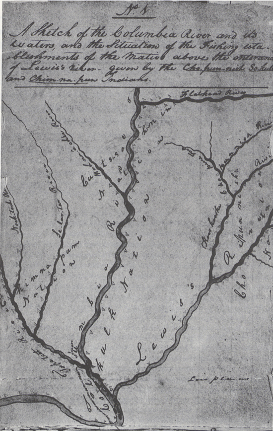
Names of this nation above the mouth of the Ki-moo-e-nim is So-Kulk Perced noses The Names of the nation on the Kimoenim River is Cho-pun-nish Piercd noses at the Prarie the name of a nation at the Second forks of the Tape tete River, or Nocktock fork Chim-nâ-pum, Some of which reside with the So kulks above this—at and a few miles distance,— 4 men in a Canoe come up from below Stayed a fiew minits and returned. [1]

ca. October 18, 1805, Elkskin-bound Journal
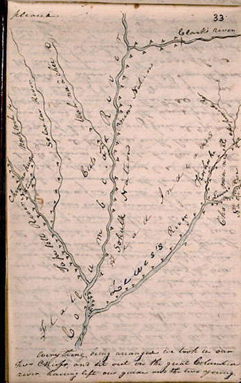
Took a meridian altitude 68° 57' 30" the Suns upper Limb. The Lattitudes produced is 46° 15' 13 9/10" North, Capt Lewis took a vocabillary of the So kulk or Pierced noses Language and Chim-nâ-pum Language whic is in Some words different but orriginally the Same people The Great Chief Cuts-Sâh nim gave me a Sketch of the rivers & Tribes above on the great river & its waters on which he put great numbers of villages of his nation & friends, as noted on the Sketch—
The fish being very bad those which was offerd to us we had every reason to believe was taken up on the Shore dead, we thought proper not to purchase any, we purchased forty dogs for which we gave articles of little value, Such as beeds, bell, & thimbles, of which they appeard verry fond, at 4 OClock we Set out down the Great Columbia accompand by our two old Chiefs, one young man wished to accompany us, but we had no room for more, & he could be of no Service to us
The Great Chief Continued with us untill our departure.
| S. 55° E [2] | 12 | miles a Lard. bend lower part of a bad rapid and Several little Stony Islands passed an Island imediately in the mouth of the Ki moo e-nim one in the mid river at 8 miles this Island of Cors gravel and 3 miles long, the Columbia more than a mile wide, banks low not Subject to over flow. an Island on the Stard. Side 〈and below〉 from opd. the Center the last 3½ miles long. no timber in view opsd. the Center of this Island and below the last a Island [3] in the middle with 9 Lodgs and a great quantity of fish on its upper point, a Small Island imediately below opsd. the upper Pt. of which the rapid Comense Several Small on the Lard Side |
| S. 20° E | 3 ½ | miles to 2 Lodges of Indians on a Small Island Stard. point 〈here the River enters Comenses a high Countrey〉 |
| S. E. | 1 ½ | miles to mo. of a 〈Creek〉 river 40 yds wide under a high Clift. in the Lard. bend here the river enters the high countrey rising abt. 200 feet above the Water large black rocks makeing out from Lard. half across the river and some distance from Stard. Side. |
| S. 12° W. | 4 | miles to a point of rocks in a Lard. Bend passed a Small Isd. passed a 2d at 2 miles, on its upr. Point 2 Lodges of Indians fishing at a rapid opsd. the lower point psd. 9 Lodges of Indians fishing on an Island on the Stard. Side below about 1 mile 5 Lodges on the Stard. Side, passed a Island in middle of river at 3 m. |
| 21 |
October 16–18, 1805, Elkskin-bound Journal
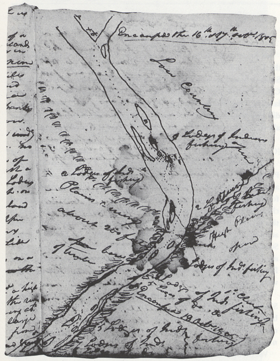
we Encamped a little below & opsd. the lower point of the Island on the Lard. Side [4] no wood to be found we were obliged to make use Small drid willows to Cook— our old Chief informed us that the great Chief of all the nations about lived at the 9 Lodges above and wished us to land &c. he Said he would go up and Call him over they went up and did not return untill late at night, about 20 came down & built a fire above and Stayed all night. The chief brought a basket of mashed berries.
[Clark]
This morning Cool and fare wind from the S. E. Six of the large Prarie cock killed this morning. Several canoes of Indians Came down and joined those with us, we had a council with those in which we informed of our friendly intentions towards them and all other of our red children; of our wish to make a piece between all of our red Children in this quarter &c. &c. this was conveyed by Signs thro: our 2 Chiefs who accompanied us, and was understood, we made a 2d Chief and gave Strings of wompom to them all in remembrance of what we Said— four men in a Canoe came up from a large encampment on an Island in the River about 8 miles below, they delayed but a fiew minits and returned, without Speaking a word to us.
The Great Chief and one of the Chim-nâ pum nation 〈gave〉 drew me a Sketch of the Columbia above and the tribes of his nation, living on the bank, and its waters, and the Tâpe têtt river which falls in 18 miles above on the westerly side See Sketch below for the number of villages and nations &c. &c. [6]
ca. October 18, 1805, Codex H, p. 33
ca. October 18, 1805, Voorhis No. 4
We thought it necessary to lay in a Store of Provisions for our voyage, and the fish being out of Season, we purchased forty dogs for which we gave articles of little value, Such as bells, thimbles, knitting pins, brass wire & a few beeds all of which they appeared well Satisfied and pleased.
every thing being arranged we took in our Two Chiefs, and Set out on the great Columbia river, haveing left our guide and the two young men two of them 〈not〉 enclined not to proceed on any further, and the 3rd could be of no Service to us as he did not know the river below
Took our leave of the Chiefs and all those about us and proceeded on down the great Columbia river passed a large Island at 8 miles about 3 miles in length, a Island on the Stard. Side the upper point of which is opposit the center of the last mentioned Island and reaches 3½ miles below the 1st. Island and opposit to this near the middle of the river nine Lodges are Situated on the upper point at a rapid which is between the lower point of the 1st Island and upper point of this; great numbers of Indians appeared to be on this Island, and emence quantites of fish Scaffold we landed a few minits to view a rapid which Commenced at the lower point, passd this rapid which was verry bad between 2 Small Islands two Still Smaller near the Lard. Side, at this rapid on the Stard. Side is 2 Lodges of Indians Drying fish, at 2½ miles lower and 14½ below the point passed an Island Close under the Stard. Side on which was 2 Lodges of Indians drying fish on Scaffolds as above at 16 miles from the point the river passes into the range of high Countrey at which place the rocks project into the river from the high clifts which is on 〈both〉 the Lard. Side about ⅔ of the way across those of the Stard Side about the Same distance, the Countrey rises here about 200 feet above The water and is bordered wth black rugid rocks, [7] at the Commencement of this high Countrey on Lard Side a Small riverlet falls in [8] which appears to passed under the high County in its whole cose Saw a mountain bearing S. W. conocal form Covered with Snow. [9] passed 4 Islands, at the upper point of the 〈first〉 3rd is a rapid, on this Island is two Lodges of Indians, drying fish, on the fourth Island Close under the Stard. Side is nine large Lodges of Indians Drying fish on Scaffolds as above at this place we were called to land, as it was near night and no appearance of wood, we proceeded on about 2 miles lower to Some willows, at which place we observed a drift log formed a Camp on the Lard Side under a high hill nearly opposit to five Lodges of Indians; Soon after we landed, our old Chiefs informed us that the large camp above "was the Camp of the 1st Chief of all the tribes in this quarter, and that he had called to us to land and Stay all night with him, that he had plenty of wood for us &" This would have been agreeable to us if it had have been understood perticelarly as we were compelled to Use drid willows for fuel for the purpose of cooking, we requested the old Chiefs to walk up on the Side we had landed and call to the Chief to come down and Stay with us all night which they did; late at night the Chief came down accompanied by 20 men, and formed a Camp a Short distance above, the chief brought with him a large basket of mashed berries which he left at our Lodge as a present. I saw on the main land opposit those Lodges a number of horses feeding, we made 21 miles to day.
[Ordway]
Friday 18th Oct. 1805. a clear pleasant morning. we delayed here untill after 12 oClock to day Capt. Clark measured Columbian River and the Ki mo e nem Rivers and found the Columbia River to be 860 yards wide, and the ki moo e nem R. to be 475 yards wide at the forks. [10] Capt. Lewis Compleated his observations and found the Latitude to produce [blank] North our officers compared several of the natives languages and found these to be of the flat head nation but another tribe. about 2 oClock P. M. we Set out. two chiefs continued on with us. we proceeded on down the great Calumbia River which is now verry wide about ¾ of a mile in General the country in general Smooth plains for about 10 miles down then the barron hills make close to the River on each Side passed Several Smooth Islands on which was large fishing Camps. large quantity of Sammon on their Scaffels. we Saw a great many dead Sammon floating in the River, and Saw the living jumping verry thick. we Saw a great nomber of horses near Some Indian villages the lodges of which was made of flags and large grass verry neatly worked. [11] we passed over Several rapids. no timber along the Shores. we Camped on the Lard Side at a fiew willows which we got to burn. a nomber of the Savages came to our Camp in Small canoes.—
[Gass]
Friday 18th. This was also a fine day and we remained here till after 12 o'clock. In the forenoon our Commanding Officers were employed in getting specimens of the language of the natives, there being three, or part of three, different nations here. [12] They are almost without clothing, having no covering of any account, except some deer skin robes and a few leggins of the same materials. The women have scarce sufficient to cover their nakedness.— Capt. Lewis had an observation at noon, which gave 46° 15 13.9 north latitude. At one we proceeded on down the Great Columbia, which is a very beautiful river. The course is something to the east of south for about 12 miles and then winds round to almost a west course. We passed some islands and a number of the camps of the natives, which appear to be very shy and distant. We went 21 miles and halted close below an Indian camp; where they have thirty canoes; and a great quantity of dried fish.
[Whitehouse]
〈Wednesday〉 Friday 18th Oct. 1805. a clear pleasant morning. we delay untill after 12 oClock today for Capt. Lewis to complete his observations. Capt. Clark measured the width Columbian River and the ki-mooe-nem found the Columbian R. to be 860 yards wide and the ki-moo-e-nem River to be 475 yards wide at the forks. Some of the party killed Several more haith hens about 12 oClock we loaded up the canoes. Capt. Lewis took down Some of three languages of these Savages, as fer as we could make them understand. about 2 oClock P. m. we Set out only two chiefs with us who come with us from the flat heads. we proceeded on down the Columbia River, which is now verry wide from a half a mile to three forths wide and verry Smooth & pleasant the country level for about 16 miles down then the hills and clifts made near the River, and Some Rapid places in the River. passd. Several Islands on which was large camps of Indians and Scaffels of abundance of Sammon. Saw the Sammon thick jumping in the river Some dead in the R. and along the Shore. the Latitude at the forks as taken by Capt. Lewis and Clark is [blank] North. we proceeded on over Several rapids places passd. Several large Camps of Indians which have flag lodges and abundance of Sammon, and have a great nomber of horses. we went [blank] miles and Saw no timber of any acct. not a tree to be Seen. we Camped on the Lard Side. got a fiew Small willows only to burn. a nomber of the natives came in their canoes to See us. they have a great nomber of Small canoes &c.—
Friday October 18th A clear pleasant morning. Our officers delayed till after 12 o' Clock A. M. to compleat & prove the observation that they had taken Yesterday, and to make farther remarks on those Two Rivers which we are now at. Captain Clark measured the width of both these Rivers. He found the Columbia River (or North fork) to be 860 Yards wide at its Mouth, & the Ki-o-me-num or Lewis's River to be 475 Yards wide at its Mouth also.— Several Men of our party went out in the plains, & killed a number more of Priari or heath hens, which were very large.— Captain Lewis took down in writing, a number of Words spoken by these Indians in their language, & the names of several things, as well as we could make them understand by signs &ca— About 2 o'Clock P. M. we proceeded again on our Voyage; and had Two Chiefs with us, that had come from the flatthead Nation of Indians. We proceeded on down the Columbia River, & found it to be from half to three quarters of a Mile wide, & the water running very smooth. The Country for about 10 Miles level, & then the hills made in near to the River & some Rapid places in it.— We passed several Islands, on which were large Camps of Indians.—
We saw likewise abundance of Scaffolds with Salmon drying on them. The Salmon were very plenty as we came along, & a number of them were jumping in the River as we passed along also, & a number of dead Salmon, lay all along the shores in the River. The Latitude at the forks of the two Rivers we last left taken by Captain Lewis & Captain Clark being fully ascertained is 46° 15' 13 7/10s North as before mentioned.— We continued on our way, & passed over several bad rapid places. We also passed several large Camps of Indians, who had Lodges built of flags, and they had abundance of Salmon. These Indians had a vast number of Horses. We saw no Timber of any account, & were forced to make use of dry Willows for fuel to cook with, some few of which grew along the Shore, where we encamped. We encamped on the South side of the River where a number natives came shortly after in their Canoes to see us. We came 17 Miles this day, our Course still being West.—

