October 22, 1805
[Clark]
a fine morning Calm. we Set out at 9 oClock and on the Course S. 52° W. 10 miles passed lodges & Inds. and rapids as mentioned in the Cours of yesterday, from the expiration of
| S. 30° W. | 3 | miles to the mouth of a large river [1] in the Lard. bend 200 yds wide great rapids in it a ¼ up it long and impracticable of assent Passed [words illegible, crossed out] a point of rock Island at 2 miles on the Stard. 3 Islands in the mouth of this river no bottoms a little up— |
| West [2] | 4 | miles to a bend on Stard. Side passed the Island of rocks at 2 miles at Lower point 8 large Lodges, on the Stard. Side 10 Lodges, below at the end of the Course 6 more Lodges passd. a Island on the Stbd. Side. |
| S. W. | 2 | miles to a rocky Lard. bend 〈passed〉 from the mouth of the river at the fall or Comencment of the Pitch where we made a portage of 457 yards & down a Slide |
| 19 [3] |
Took our Baggage & formed a Camp below the rapids in a cove on the Stard Side [4] the distance 1200 yards haveing passed at the upper end of the portage 17 Lodges of Indians, [5] below the rapids & above the Camp 5 large Loges of Indians, great numbers of baskets of Pounded fish on the rocks Islands & near their Lodges thos are neetly pounded & put in verry new baskets of about 90 or 100 pounds wight. hire Indians to take our heavy articles across the portage purchased a Dog for Supper Great numbers of Indians view us, we with much dificuely purchd. as much wood as Cooked our dogs 〈& fish〉 this evening, our men all in helth— The Indians have their grave yards on an Island in the rapids. The Great Chief of those Indians 〈are〉 is out hunting. no Indians reside on the Lard Side for fear of the snake Indians with whome they are at war and who reside on the large fork on the lard. a little above
[Clark]
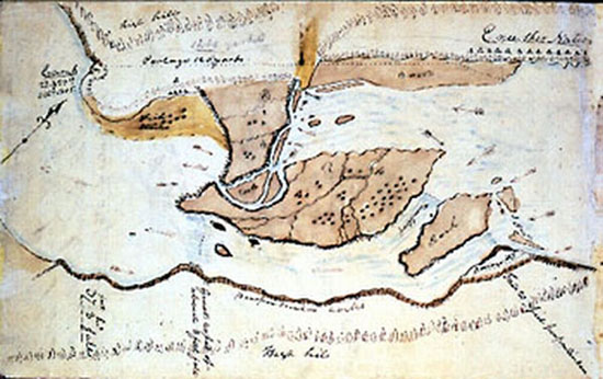
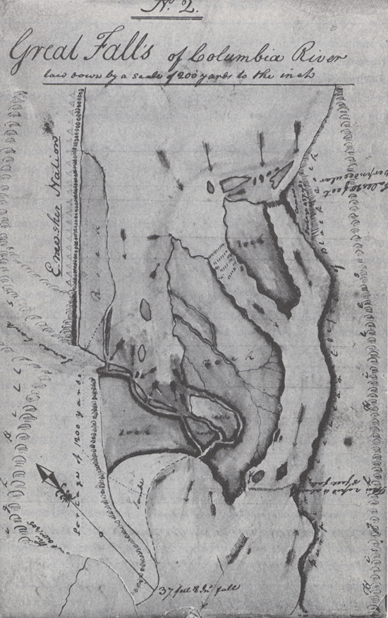
A fine morning calm and fare we Set out at 9 oClock passed a verry bad rapid at the head of an Island close under the Stard. Side, above this rapid on the Stard. Side is Six Lodges of nativs Drying fish, [6] at 9 mls. passed a bad rapid at the head of a large Island of high, uneaven [rocks], jutting over the water, a Small Island in a Stard. Bend opposit the upper point, on which I counted 20 parcels of dryed and pounded fish; on the main Stard Shore opposit to this Island five Lodges of Indians are Situated [7] Several Indians in Canoes killing fish with gigs, 〈and nets〉 &c. opposit the center of this Island of rocks which is about 4 miles long we discovered the enterence of a large river on the Lard. Side which appeared to Come from the S. E.— we landed at Some distance above the mouth of this river and Capt. Lewis and my Self Set out to view this river above its mouth, as our rout was intersepted by a deep narrow Chanel which runs out of this river into the Columbia a little below the place we landed, leaveing a high dry rich Island [8] of about 400 yards wide and 800 yards long here we Seperated, I proceeded on to the river and Struck it at the foot of a verry Considerable rapid, here I beheld an emence body of water Compressd in a narrow Chanel of about 200 yds in width, fomeing over rocks maney of which presented their tops above the water, when at this place Capt. Lewis joined me haveing delayed on the way to examine a root of which the nativs had been digging great quantities in the bottoms of this River. [9] at about two miles above this River appears to be confined between two high hils below which it divided by numbers of large rocks, and Small Islands covered with a low groth of timber, and has a rapid as far as the narrows three Small Islands in the mouth of this River, 〈we returned〉 this River haveing no Indian name that we could find out, except "the River on which the Snake Indians live," we think it best to leave the nameing of it untill our return.
we proceeded on pass the mouth of this river at which place it appears to discharge ¼ as much water as runs down the Columbia. at two miles below this River passed Eight Lodges on the Lower point of the Rock Island aforesaid at those Lodges we saw large logs of wood which must have been rafted down the To war-ne hi ooks [10] River, below this Island on the main Stard Shore is 16 Lodges of nativs; here we landed a fiew minits to Smoke, the lower point of one Island opposit which heads in the mouth of Towarnehiooks River which I did not observe untill after passing these lodges about ½ a mile lower passed 6 more Lodges on the Same Side and 6 miles below the upper mouth of Towarnehiooks River the comencement of the pitch of the Great falls, [11] opposit on the Stard. Side is 17 Lodges of the nativs we landed and walked down accompanied by an old man to view the falls, and the best rout for to make a portage which we Soon discovered was much nearest on the Stard. Side, and the distance 1200 yards one third of the way on a rock, about 200 yards over a loose Sand collected in a hollar blown by the winds from the bottoms below which was disagreeable to pass, as it was Steep and loose. at the lower part of those rapids we arrived at 5 Large Lodges of nativs drying and prepareing fish for market, they gave us Philburts, [12] and berries to eate, we returned droped down to the head of the rapids and took every article except the Canoes across the portag where I had formed a camp on ellegable Situation for the protection of our Stores from Thieft, which we were more fearfull of, than their arrows. we despatched two men to examine the river on the opposit Side, and reported that the Canoes could be taken down a narrow Chanel on the opposit Side after a Short portage at the head of the falls, at which place the Indians take over their Canoes. Indians assisted us over the portage with our heavy articles on their horses, the waters is divided into Several narrow chanels which pass through a hard black rock forming Islands of rocks at this Stage of the water, [13] on those Islands of rocks as well as at and about their Lodges I observe great numbers of Stacks of pounded Salmon 〈butifully〉 neetly preserved in the following manner, i e after Suffiently Dried it is pounded between two Stones fine, and put into a speces of basket neetly made of grass and rushes [14] of better than two feet long and one foot Diamiter, which basket is lined with the Skin of Salmon Stretched and dried for the purpose, in theis it is pressed down as hard as is possible, when full they Secure the open part with the fish Skins across which they fasten tho' the loops of the basket that part very Securely, and then on a Dry Situation they Set those baskets the Corded part up, their common Custom is to Set 7 as close as they can Stand and 5 on the top of them, and secure them with mats which is raped around them and made fast with cords and Covered also with mats, those 12 baskets of from 90 to 100 w. each 〈basket〉 form a Stack. thus preserved those fish may be kept Sound and Sweet Several years, as those people inform me, Great quantities as they inform us are Sold to the whites people who visit the mouth of this river as well as to the nativs below.
and Oregon, October 22–23, 1805, Codex H, p.1
on one of those Island I saw Several tooms but did not visit them— The principal Chiefs of the bands resideing about this Place is out hunting in the mountains to the S. W.— no Indians reside on the S. W.— side of this river for fear (as we were informed) of the Snake Indians, who are at war with the tribes on this river—. they represent the Snake Indians as being verry noumerous, and resideing in a great number of villages on Towarnehiooks River which falls in 6 miles above on the Lard. Side and is reaches a great ways and is large a little abov its mouth at which part it is not intersepted with rapids, they inform that one considerable rapid & maney Small ones in that river, and that the Snake live on Salmon, and they go to war to their first villages in 12 days, the Couse they pointed is S. E. or to the S of S. E. we are visited by great numbers of Indians to Day to view us, we purchased a Dog for Supper, Some fish and with dificuelty precured as much wood as Cooked Supper, which we also purchased we made 19 miles to day
and Oregon, October 22–23, 1805, Voorhis No. 4
[Ordway]
Tuesday 22nd Oct. 1805. a fair morning. we Set out at Sunrise and proceeded on. passed a number of fisheries and a high Island which had towers of Solid rocks and verry high and rough. a roaring rapid at the Stard Side we went down a narrow channel on the Lard. Side a large river [15] puts in verry rapidly of the Island about 40 yards wide Several perpinticular falls near its mouth. large fishing Camps at the lower end of the Island. this Isd. is about 4 miles in length and high rough & rockey. a Short distance below we came to the first falls of the Columbia River. [16] we halted about noon a Short distance above at a large Indian villages. the huts of which is covred with white ceeder bark these Savages have an abundance of dry and pounded Sammon we bought Some from them and Some flag & grass mats &C. they have a number of small canoes and a fiew horses our officers viewed the falls and found that we had a portage of about ¾ of a mile, on the Stard. Side. So we went at carrying the baggage past the portage. hired Some horses from the natives to take the heavey baggage past, &C. [illegible letters] we got all except the canoes below the falls and camped close under a high range of clifts of rocks, where the body of the River beat against it and formed a verry large eddy. we Saw a number of large Sea otter [17] below the falls in the whorl pools and eddys the natives are verry troublesome about our Camp—
[Gass]
Tuesday 22nd. The morning was fine and we went on early, and saw a great number of ducks, [18] geese and gulls. At 10 o'clock we came to a large island, where the river has cut its way through the point of a high hill. Opposite to this island a large river comes in on the south side, called by the natives the Sho-sho-ne or Snake-Indian river; and which has large rapids close to its mouth. This, or the Ki-moo-ee-nem, is the same river, whose head waters we saw at the Snake nation. [19]
The natives are very numerous on the island and all along the river. [20] Their lodges are of bulrushes and flags, [21] made into a kind of mats, and formed into a hut or lodge.
About 3 miles lower down we came to the first falls or great rapids; and had 1300 yards of a portage over bad ground. All our baggage was got over this evening and we encamped with it; but are not certain whether we can take our canoes by water. Our voyage to day, to the head of the rapids or falls was 18 miles.
[Whitehouse]
Tuesday 22nd Oct. 1805. a clear pleasant morning. we Set out Soon after Sunrise and proceeded on passed fishing Camps on the Stard. Side high clifts on each Side of dark couloured rock, and a high rock Island with rough towers of Solid rough rocks on it a verry rough roaring rapid at the Stard. Side which is the main body of the River we went down on the Lard. Side a river puts in on the Lard. Side about 40 yards wide & falls in it. opposite the lower part of the Island high hills & clifts on each Side, but the highest is on the Stard Side. all the natives on this River at the most of their Camps have fish nets which they catch the Sammon in the Spring in great abundance. Saw considerable of Sand along the Shores for Several days past. we proceeded on to the lower end of Sd. Island which is about 4 mile long at the lower end is a great nomber of fishing Camps a Short distance below is the first falls of the Columbian River. we halted little above about noon and bought Some pounded fish and root bread of the natives who are verry thick about these falls. Some of them have [f]lag lodges and Some have cabbins of white ceeder bark they have an abunduance of dry and pounded [fish?]. bags full of Sammon and heaps of it on the Shores they have a nomber of Small canoes, and have a nomber of well looking horses. high clifts of rocks near on each Side of the falls. we found the falls to be about [blank] feet of a perpinticular pitch and filled with Solid rocks cut in many channels. a mist rises contiuually from the falls. we found that we had to make a portage of about ¾ of a mile on the Stard. Side. So we went to carrying the baggage by land on our backs. hired a fiew horse loads by the natives So we got all the baggage below the falls this evening and Camped close to a high range of clifts of rocks, where the body of the River beat against it and formed a large Eddy. the natives Sign to us that it is only about Six miles below, to the next or other falls. we Saw Several Sea otter in and about these falls. the natives are troublesome about our Camp. we had went about [blank] miles before we came to these falls. these natives Sign to us that Some white people had been here but were gone four or 5 days journey further down. the perpinticular clifts at our Camp is [blank] feet high.
Tuesday October 22nd A clear pleasant morning & We set out soon after Sun rise & proceeded on down the River, we passed several fishing Camps of Indians, lying on the North side of the River, and high Clifts of dark colour'd Rock lying on both sides of it.— We also saw an Island of Rocks, which had towers of solid Rock on it, and a very rough roaring rapid, lying on the North side of the River, on which lies the main Channel & body of it; We proceeded down at this place on the South side of the River & found a small River, which emtied into the Columbia River on the same side. It appeared to be about 40 Yards wide, & fell into it opposite to the lower part of the Rockey Island. This River was called the Sho-sho-ne or Clark's River. We saw high hills & Clifts of rocks, which lay on both sides of the River, the highest of which lies on the North side of it. We found that the Natives had fishing Seins which we saw during this day, and catch the greatest abundance of fish with them in the Spring of the Year. The Sand this day, lays in great abundance along the Shores.— We continued on to the lower end of the Island before mention'd this day, (which we supposed to be at least 4 Miles in length) & found a great number of fishing Camps, a short distance below it, We came here, to the first falls of Columbia River where we halted, for a short time a small distance above it, about noon. The Natives at this place came to us, and we purchased from them some pounded Salmon, & Root bread, which they had brought with them.— We found the Natives to be very numerous about those falls. They had a number of lodges made out of Flags & Cedar bark, and Cabbins built out of same kind of Cedar wood & covered with Bark; we found also among them, large quantities of dried Salmon, which they had in grass bags of their own manufacture, & we saw a number of small Canoes lying along the Shores of the River. We saw a number of handsome horses feeding in the plains which belonged to the Natives. These falls were perpendicular & we found them by measurement to be about 37 feet 8 Inches feet high, & full of Solid Rocks which by the force of the rapidity of the Waters running, are cut into many Channels. And a constant mist rises at this place occasioned by the great fall of Water. The River at this place 〈is〉 was considerable narrower than it was a few Miles above it.—
The Rocks & Clifts lay very high near to the River; on both sides of these falls; & the Water falling in such an immense quantity, makes a roaring that can be heard several miles below it. We found that we should be forced to make a portage of about ¾ of a Mile to get where we could again load our Canoes with safety, to proceed on our Voyage. Our Men were set to carrying on their backs all our Goods baggage &ca. and our officers hired from the Natives a few horses, to carry the most weighty part of it. We got all our baggage safe below these falls, in the Evening and encamped on the North side of the River, close to a high range of Clifts of rocks, where the Main body of the Water ran against them & formed a very large Eddy.— The Natives made signs to us, which we understand to be that about 6 Miles below this falls, that we shall come to another great falls. We saw a number of Sea Otters, in and about these falls. We found the Natives here very troublesome about our camp and we 〈are〉 were forced to watch them, for fear of their stealing from us.— These Natives informed us by signs, that some White people had been at this place, but that they had gone 4 or 5 days Journey down the River. The perpendicular hight of the Clifts were we are encamped, is about 250 feet high. We came about 35 Miles this day our course being as usual West.—
| Opposite this course is a column of figures: | 17 |
| 21 | |
| 36 | |
| 42 | |
| 33 | |
| 19 | |
| 168 |

