October 13, 1805
[Clark]
rained a little before day, and all the morning, a hard wind from the S West untill 9 oClock, the rained Seased & wind luled, and Capt Lewis with two Canoes Set out & 〈Crossed〉 passed down the rapid The others Soon followed and we passed over this bad rapid Safe. We Should make more portages if the Season was not So far advanced and time precious with us
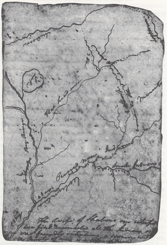
| S. 20° W | 2 | miles to a Lard Bend passed in the greater part of the dis- tance thro a bad rapids, rocks in every derection. Channel on the Lard Side about the center of the long rapid— |
| S. 70° W | 3 | miles to a large Creek in the Ld. bend. passed a bad rockey rapid at 2 miles many rocks |
| N. 50° W. | 5 | miles to a large Creek Std. bend [X: at 2 Indian cabins] passed a bad rapid for 4 miles Water Compressed in a nar- row Channel not more than 25 yards for about 1½ miles Saw Several Indians, this place may be called the narrows or narrow rapid 〈great fishery〉 |
| N. 75° W. | 2 | miles to the Stard. bend |
| S W. | 2 ½ | miles to a Lard. bend |
| N. 80° W. | 3 | miles to a Stard. bend |
| S. 60° W. | 2 | miles on the Std. Side passed a rapid |
| S. 40° W. | 3 ½ | miles to a Lard. bend high Clifts the parts of an Indian house Scaffoled up on the Lard Sd. opposit a Picketed grave yard we Came to on the Stard. Side & Camped. Two Indians whome we left at the forks over took us on horseback & wishes to accompany us, no game [1] |
| 23 |
ca. October 13, 1805, Elkskin-bound Journal
The wife of Shabono our interpetr we find reconsiles all the Indians, as to our friendly intentions a woman with a party of men is a token of peace
[Clark]
a windey dark raney morning The rain commenced before day and Continued moderately untill near 12 oClock— we took all our Canoes 〈over〉 through This rapid without any injurey. a little below passed through another bad rapid at [blank] miles passed the Mo: of a large Creek [ML?: at 5 m in the Lard. bend we call Ki-moo-e-nimm Creek ] [2] [ML?: 10 Ms.] little river in a Stard. bend, imediately below a long bad rapid [ML?: drewyers River ] [3]; in which the water is Confined in a Chanel of about 20 yards between rugid rocks for the distance of a mile and a half and a rapid rockey Chanel for 2 miles above. This must be a verry bad place in high water, here is great fishing place, the timbers of Several houses piled up, and a number of wholes of fish, and the bottom appears to have been made use of as a place of deposit for their fish for ages past, here two Indians from the upper foks over took us and continued on down on horse back, two others were at this mouth of the Creek— we passed a rapid about 9 mile lower. at dusk came to on the Std. Side & Encamped. [4] The two Inds. on horse back Stayed with us. The Countery Thro' which we passed to day is Simlar to that of yesterday open plain no timber passed Several houses evacuated at established fishing places, [5] wind hard from The S. W. in the evening and not very cold
[Ordway]
Sunday 13th Oct. 1805. a rainy morning. wind high. delayed untill about 10 oClock then took down one canoe at a time below the rapids. all the men who could not Swim Carried each a load of baggage by land. about 12 we got Safe below the rapids at 2 oClock cleared off. Saw a great number of fishing camps where the natives fish everry Spring. they raft all their wood down the River a long distance and they put it up on Scaffels and take great care of it. towards evening we passed through a place in the River where it was all confined in a narrow channel of about 15 yards wide for about 2 miles and ran like a mill race large fisherys below in the Spring. Saw 2 Indians Swim their horses across the river to the N. Side and went on down the River. passed a creek [6] which came in on the Lard. Side this afternoon the current Swift. the barrons and plains continue as usal.
[Gass]
Sunday 13th. This was a cloudy wet morning, and we did not set out till 11 o'clock: we then proceeded with two canoes at a time over the rapids, which are about 2 miles in length; and in about two hours got all over safe. We then went on again and passed more bad rapids, but got through safe. In the afternoon the weather cleared and we had a fine evening. Having gone 23 miles we encamped on the north side. The country continues much the same, all high dry prairie. One handsome creek [7] comes in on the south side.
[Whitehouse]
〈Friday〉 Sunday 13th Oct. 1805. a rainy wet morning. we delayed untill about 10 oClock A. m. then took 2 of the canoes at a time down the rapids. all the men which could not Swim went by land and carried Some rifles & Instruments &c. we got Safe below the rapids by 12 oClock. dined on Sammon and proceeded over Several more rapids the wind hard a head. cleard off about 2 oC. P. m. we Saw Several Old camps where the natives fish in the Spring, but no timber except what they raft down a long distance, and they Scaffel it up verry carefully. towards evening we came to a verry rockey place in the River & rapid the River all confined in a narrow channel only about 15 [8] yds. wide for about 2 mile and ran as [s]wift as a mill tale the canoes ran down this channel Swifter than any horse could run. a great fishery below these rapids. Saw 2 Indians Swim their horses across the River to the N. S. and follow down the River they have to ride fast to keep up with us for the current mostly rapid. the clifts & hills high plains & barrons continues on each Side of the River as usal. we Came [blank] miles this day and Camped on the Stard Side. passed a Creek on the Lard. Side this aftr. noon.
Sunday October 13th This morning we had Rain & delayed setting out till about 10 o'Clock A. M. We took 2 of our Canoes at a time down the Rapids. The Men that were among us, that could not swim, went by land, to go below these Rapids. They carried with them some Rifle Guns & Mathematical Instruments &ca. We were fortunate in getting all our Canoes safe over these Rapids, by 12 o'Clock A. M. when we halted to dine on Salmon. We proceeded on our Voyage about 2 o'Clock P. M. & passed several old fishing Camps, where the Natives come to catch Salmon in the spring of the Year. We crossed several more Rapids which were not difficult to pass. About 3 o'Clock P. M. the wind rose from the West & the Weather became clear & pleasant. We saw no Timber this day, excepting what the Natives had rafted down the River a great distance, which they Scaffold up very carefully. Towards evening we came to a very rockey place lying in the River, which run very rapid. The River at this place was confined in a narrow channell, & was only about 150 Yards wide for about 2 Miles & ran as swift as Water from a Mill tail.— Our Canoes descended the River at this place with much more swiftness than a common horse could run the same distance. We found below these falls a great Indian fishery & saw 2 Indians swim their horses across the Columbia River, to the North side of it. They followed us down the River & had to ride fast, to come up with us. The current of the River run mostly very rapid, the Hills & plains high, & some Clifts of rocks. The land is very Barren on both sides of the River as usual. We came 35 Miles from the best computation we can make this day & encamped on the North side of the River. Our Course for these several days past has been West. We passed by a Creek this afternoon lying on the South side of the River which was small.

