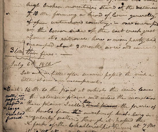
July 5, 1806
[Lewis]
Set out at 6 A. M.— steered
| N. 75 E. | 6 ½ | M. passed a stout C. N Side at 2½ M. anoth[er] just above [1] saw an old indian encampment of 11 lodges of bark and [leather?] on S. side at 3½ M. killed a deer. |
| N. 25 E. | 12 〈10〉 | m. passing a 〈large〉 small creek at 〈½〉 one m. on S sid [2] on which there is a handsom and extensive Valley and plain for 10 or 12 ms. also another creek 12 yd. wide at ½ a mile further on N. side [3] and another 8 yds. wide on 〈S.〉 N. [L?] side at 5 ms further [4] one & ½ m. short of the extremity of this course arrive at a high prarie on 〈S.〉 N. [L.?] side from one to three miles in width extending up the river. [5] halted and dined in the mouth of a little drane on the left of the plain where there was a considerable quantity of quawmash. saw a gang of antelopes [6] here of which we killed one the does at this season herd with each other and have their young. the bucks are alone there are many wild horses on Clarkes river about the place we passed it we saw some of them at a distance. there are said to be many of them about the head of the yellowstone river.— |
| East | 6 | m. to the entrance of Werner's Creek
[7] 35 yds. wide through a high extensive prairie on N. side. hills low and timbered with the long leafed pine, larch, and some fir. the road passes at some distance to the left of the river and 〈their〉 this couses 〈are〉 is with the river. |
| N. 22 W. | 4 | miles to a high insulated knob just above the entrance of a Creek 8 yards wide which discharges itself into Werners 〈run〉 Creek. [8] |
| N. 75 E. | 2 ½ | M. to the river passing through an extensive and handsom plain on Werner's Creek, crossing that creek at 1 m. and leaving a high prarie hill to the right seperating the plain from the river. saw two swan in this beautiful Creek.— |
| East | 3 | m. to the entrance of a large creek 20 yds. wide Called Seamans' Creek [9] passing a creek at 1 m. 8 yds. wide. [10] this course with the river, the road passing through an exten- sive high prarie rendered very uneven by a vast number of little hillucks and sinkholes 〈holds〉. at the heads of these two creeks high broken mountains stand at the distance of 10 m. forming a kind of Cove generally of open un- timbered country.— we encamped on the lower side of the last creek just above it's entrance. [11] here a war party had encamped about 2 months since and conceald their fires.— [12] |
| 31 m. |
July 5, 1806, Codex La, p. 4
[Clark]
I rose at day light this morning despatched Labeash after a Buck which he killed late last evening; and I with the three men who I had Sent in Serch of a ford across the West fork of Clarks river, and examined each ford neither of them I thought would answer to pass the fork without wetting all the loads. near one of those places pointed out by Colter I found a practiable foard and returned to Camp, ordered everything packed up and after Brackfast we Set out passed 5 Chanels of the river which is divided by Small Islands in passing the 6th & last Chanel Colter horse Swam and with Some dificuelty he made the Opposite Shore, Shannon took a different derection from Colter rained his horse up the Stream and passed over very well I derected all to follow Shannon and pass quartering up the river which they done and passed over tolerably well the water running over the back of the 2 Smaller horses only. unfortunately my trunk & portmantue Containing Sea otter Skins flags Some curiosites & necessary articles in them got wet, also an esortment of Medicine, and my roots. about 1 mile we struk the East fork which had fallen and was not higher than when we passed it last fall we had not proceeded up this fork more than 1 mile eer we struck the road by which we passed down last fall and kept it at one mile we crossed the river at a very good foard and continued up on the East Side to the foot of the Mountain nearly opposite flour Crek [13] & halted to let our horses graze and dry our wet articles. I saw fresh Sign of 2 horses and a fire burning on the side of the road. I prosume that those indians are spies from the Shoshones. Shannon & Crusat killed each a deer this morning and J. Shields killed a female Ibex or bighorn on the side of the Mountain, this Animal was very meager. Shannon left his tomahawk at the place he killed his deer. I derect him to return for it and join me in the Vally on the East Side of this mountain. gave Shields permission to proceed on over to the 1st Vally and there hunt untill my arival this evening at that place, after drying every article which detained us untill ½ past 4 P. M. we packed up and Crossed the Mountain into the vally where we first met with the flatheads [14] here I overtook Shields he had not killed any thing. I crossed the river which heads in a high peecked mountain Covered with Snow N. E. of the Vally at about 20 Miles. [15] [NB: see note] [16] Shields informed me that the Flat head indians passed up the Small Creek which we came down last fall about 2 miles above our Encampment of the 4th & 5th of, Septr. I proceeded up this South branch 2 Miles and encamped on the E. side of the Creek, [17] and Sent out several men to examine the road. Shields returned at dark and informed me that the best road turned up the hill from the creek 3 Miles higher up, and appeared to be a plain beaten parth. [18] as this rout of the Oat lash shoots can be followed it will evidently Shorten our rout at least 2 days and as the indians informed me last fall a much better rout than the one we came out. at all events I am deturmined to make the attempt and follow their trail if possible if I can prosue [EC: prosue = pursue] it my rout will be nearer and much better than the one we Came from the Shoshones, & if I should not be able to follow their road; our rout can't possibly be much wors. The hunters killed two deer this evening. The after part of the day we only come 8 miles makeing a total of 20 Miles—. Shannon Came up about Sunset haveing found his tomahawk.
[Ordway]
Saturday 5th July 1806. a fair M. we took breakfast as usal and Set out to cross the right fork of the river which we found nearly Swimming. proceed. on up the river Some distance crossd. the other fork. the hunters killed a deer and a Mountain Sheep or big horn animel. about noon we halted in a bottom to dine. Shannon left his tommahawk back where he killed the deer & went back for it. we delayed about 3 hours and proceed on over the hills towards evening we came to the Smooth plains where we Saw the 1st flat heads or Tus e paw last year as we passd down. we Camped [19] on the branch & plain the hunters killed two deer. Shannon joined us with his tommahawk &C.—
[Gass]
Saturday 5th. We had another beautiful morning, set out early and proceeded on the same course as yesterday through a rough country, with a number of branches or small streams flowing from the hills. We killed one deer, and about 11 o'clock came to a valley three quarters of a mile wide, [20] all plains, where we halted to dine and to let our horses feed. The hills upon each side are handsomely covered with timber of the fir kind. While we rested here one of hunters killed a cabre or antelope. At 1 o'clock we proceeded on again up the valley. When we had gone about nine miles we came to and crossed a river, [21] about 35 yards wide, which flows in with a rapid current from some snow topped mountains on the north, [22] where the valley is two or three miles wide. Having gone about four miles further we came to the head of the valley, where the hills came close upon the river for two miles. After we had passed these narrows we came to another large and beautiful valley four or five miles wide, and all plains, except some timber on the river banks. In the evening we encamped [23] on the bank of a handsome creek which comes in from the north, bold stream of 15 yards wide.

