July 18, 1806
[Lewis]
We set out this morning a little before sunrise ascended the river hills and continued our rout as yesterday through the open plains at about 6 miles we reached the top of an elivated plain which divides the waters of the rose river from those of Maria's river. from hence the North mountains, the South mountains, the falls mountains and the Tower Mountain [1] and those arround and to the East of the latter were visible. our course led us nearly parrallel with a creek of Maria's river which takes it's rise in these high plains at the place we passed them; at noon we struck this creek about 6 ms. from its junction with Maria's river [2] where we found some cottonwood timber; here we halted to dine and graize our horses. the bed of this creek is about 25 yds. wide at this place but is nearly dry at present, the water being confined to little pools in the deeper parts of it's bed. from hence downwards there is a considerable quantity of timber in it's bottom. we passed immence herds of buffaloe on our way in short for about 12 miles it appeared as one herd only the whole plains and vally of this creek being covered with them; saw a number of wolves of both speceis, [3] also Antelopes and some horses. after dinner we proceeded about 5 miles across the plain to Maria's river where we arrived at 6 P. M. we killed a couple of buffaloe in the bottom of this river and encamped on it's west side in a grove of cottonwood some miles above the entrance of the creek. [4] being now convinced that we were above the point to which I had formerly ascended this river and faring that a fork of this stream might fall in on the Northside between this place and the point to which I had ascended it, I directed Drewyer who was with me on my former excurtion, and Joseph Fields to decend the river early in the morning to the place from whence I had returned, and examine whether any stream fell inn or not. I keep a strict lookout every night, I take my tour of watch with the men.
| N. 25 W. | 7 | ms. to the source of Buffloe Creek passing the dividing ridge between the waters of Maria's and rose [EC?: Tansy or Teton] river at 6 ms. praries more hilly than yesterday. many prickly pears now in blume. |
| N. 15 W | 12 | ms. down buffaloe Creek to the place at which we dined. here timber commences on this stream. 25 yds. wide no run- ning water. |
| North | 5 | ms. to Maria's River 130 yds. wide 3 feet deep encamped on South side.— |
| Ms. | 24 |
[Clark]
| East | 3 | miles to a Stard. Bend passing under a high pine hill on Lard Side Several Islands— 4½ |
| N. 62° E | 4 ½ | miles to the enterance of a Small Creek on a bend to Lard Side opposit to 3 Islands [5] passed Several Small Islands high lands on Std. a narrow bottom on the Lard side. Saw a great Smoke in the R mts. S 20° W. [6] the rock mts. Termo- nate S 30° W. a mtn. not So high at a long distance is S. 80° E.— 7 〈6〉 m |
| S. 78° E | 2 ½ | Miles to a bend to the Stard. Side passing Several Islands. river pass under a high ruged hill on the Lard side bad road— 4 ms. |
| East | 3 ½ | miles to a Stard Bend passing a High point at 2 miles on the Lard Side a narrow bottom on the Stard Side High hills on each Side partially Covered with pine. Country ruged and Stoney. halted in a bottom to dine. 6 ms. |
| N. 20° E | 2 | Mile to a Lard. Bend river passing under the high land on the Stard Side at 1 mile the botton on Lard Side ¼ of a mile wide. 3½ ms. |
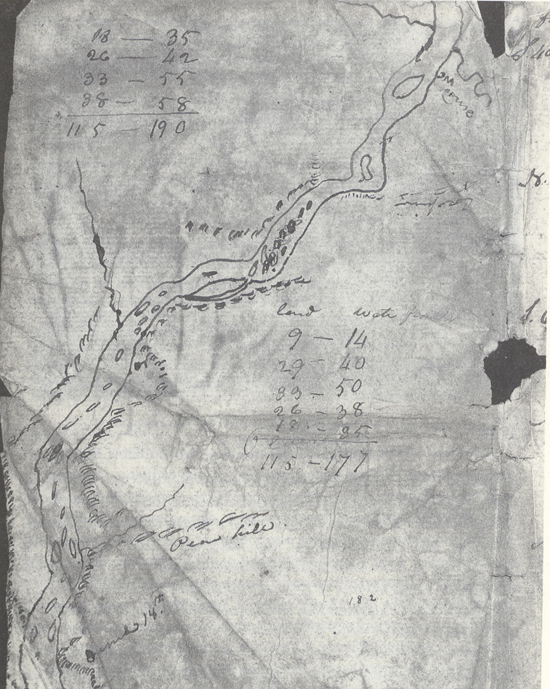
| N. 72° E | 3 ½ | miles to a bend [7] [tear] 〈passd.〉 enterance a large dr[tear] [illegible, crossed out] [tear] 〈S 45°〉 to an Indian fort on [tear] an Island divided [tear] by a narrow Chann [tear] under the Stard. Hills |
| S. 45° E | 6 | miles to a high pine hill 〈at〉 [tear] Side at the foot of which the riv[er] [pass]es haveing made Several shot bends in which there is several Islands Bottoms ½ m. wide on the Lard Side a good propotion of Cotton & Willow on the boarders of the river— 10 m |
| S. 82° E | 1 | miles to the head of a Small Isld. Close to the Lard Shore and incamped river makeing a bend to the right and passing under high lands on the Stard. Side. Killed a Buffalow— 2 〈½〉 |
July 17—18, 1806, Voorhis First Draft
[Clark]
as we were about Setting out this morning two Buffalow Bulls came near our Camp Several of the men Shot at one of them. their being near the river plunged in and Swam across to the opposit Side and there died. Shabono was thrown from his horse to day in pursute of a Buffaloe, the hose unfortunately Steping into a Braroe [8] hole fell and threw him over his head. he is a good deel brused on his hip Sholder & face. after brackfast I proceeded on as usial, passd. over points of ridges So as to cut off bends of the [NB: river] crossed a Small Muddy brook [9] on which I found great quantities of the Purple, yellow & black currents [10] ripe. they were of an excellent flavour. I think the purple Superior to any I have ever tasted. The river here is about 200 yards wide rapid as usial and the water gliding over corse gravel and round Stones of various sizes of an excellent grite for whetestones. the bottoms of the river are narrow. the hills are not exceeding 200 feet in hight the sides of them are generally rocky and composed of rocks of the same texture of a dark Colour of Grit well Calculated for grindstones &c. The high bottoms is composed of gravel and Stone like those in the Chanel of the river, with a mixture of earth of a dark brown colour [11] The Country back from the river on each Side is generally open wavering plains. Some pine is to be Seen in every direction in those plains on the Sides of hills &c. at 11 A. M. I observed a Smoke rise to the S. S. E in the plains towards the termonation of the rocky mountains in that direction (which is Covered with Snow) this Smoke must be raisd. by the Crow Indians in that direction as a Signal for us, or other bands. I think it most probable that they have discovered our trail and takeing us to be Shoshone &c. in Serch of them the Crow Indians [WC: now at peace with them] to trade as is their Custom, have made this Smoke to Shew where they are—or otherwise takeing up to be their Enemy made this Signal for other bands to be on their guard. I halted in a bottom of fine grass to let the horses graze. Shields killed a fat Buck on which we all Dined. after dinner and a delay of 3 hours to allow the horses time to feed, we Set out at 4 P. M. I set out and proceeded down the river through a butifull bottom, passing a Indian fort on the head of a Small island near the Lard Shore and Encamped on a Small Island Seperated from the Lard Shore by a very narrow Chanel. [12] Shields killed a Buffalow this evening which Caused me to halt sooner than Common to Save Some of the flesh which was So rank and Strong that we took but very little. Gibson in attempting to mount his horse after Shooting a deer this evening fell and on a Snag and sent it nearly [NB: two] inches into the Muskeler part of his thy. he informs me this Snag was about 1 inch in diamuter burnt at the end. this is a very bad wound and pains him exceedingly. I dressed the wound.

July 18, 1806, Voorhis First Draft
|
Ms. by water |
||||
| East | 3 | Miles to a Stard. Bend passing at the foot of a high | } | 4 ½ |
| pine hill rocky and Steep on the Lard. Side. | ||||
| passed several Islds. | ||||
| N. 62° E | 4 ½ | Miles on the course to the enterance of a Small | } | 7 |
| Creek in a Lard. Bend opposit to three Islands | ||||
| passing Several Small Islands, high lands on the | ||||
| Stard. Side bottoms narrow on the Lard Side | ||||
| (Saw a smoke S. 30° W.[)] discover the Big horn | ||||
| mountain which is low at S. 80° E. | ||||
| S. 78° E. | 2 ½ | Miles on the Course to a bend on the Stard Side | } | 4 |
| passed Several Islands. river washing the base of | ||||
| a high ruged Stoney hill on the Lard Side | ||||
| East | 3 ½ | Miles on the course to a Stard. Bend passing a | } | 6 |
| high point at 2 Miles on the Lard. Side a narrow | ||||
| bottom on the Stard. Side. the hills are high on | ||||
| each Side partially covered with pine. Country | ||||
| ruged and Stoney emence qtty of Prickley pears [13] | ||||
| N. 20° E. | 2 | Miles on the Course to a Lard Bend. river wash- | } | 3 ½ |
| ing the base of the high land on the Starboard | ||||
| Side at one mile. the bottoms on the Larboard | ||||
| wide a quarter of a mile wide— | ||||
| N. 72° E. | 3 ½ | Miles on the Course to a Lard Bend passd. the | } | 5 |
| enterance of a large dry Creek & 3 islands an old | ||||
| indian fort on an Island close to the Lard | ||||
| Shore. river washing the foot of the Stard. Hills | ||||
| S. 45° E. | 6 | Miles on the course to a high hill on the Stard. | } | 11 |
| Side at the foot of which the river passes, haveing | ||||
| made Several Short bends in which there is Several | ||||
| islands. the bottoms ½ a mile wide on the Stard | ||||
| Side. a good proportion of Cotton wood and | ||||
| willow on the borders of the river on each Side. | ||||
| S. 82° E. | 1 | Mile to the head of a Small island close to the Lard | } | 2 |
| Shore. river makeing a bend to the Stard. under | ||||
| the high lands which is ruged and Stoney en- | ||||
| camped on the Island Gibson Snaged his thye | ||||
| Ms. | 26 | by land by water | Ms. | 43 |
[Ordway]
Friday 18th July 1806. a clear cool windy morning. we set off as usal and proceeded on down the gentle current Saw large gangues of buffaloe out in the plains about noon Collins killed three deer. Saw great numbers of beaver and otter &C. towards evening we passed the mouth of Smiths River [14] a Short distance below Some of the hunters went out after some gangues of buffaloe and we Camped it being late the hunters did not kill any this evening but Saw great numbers in the plains. the Musquetoes and Small flyes are verry troublesome. my face and eyes are Swelled by the poison of those insects which bite verry Severe indeed.
[Gass]
Friday 18th. There was another plesant day, and I went down with three of the men to the lower end of the portage [15] to examine the periogue and deposit there, and found all safe. We took some tobacco out of the deposit, covered up all again, until the party should arrive with the canoes, and returned to camp.

