September 2, 1804
[Clark]
2nd of Sept. Sunday 1804— Set out early & proceeded on passed the Island & Came too above below 〈under〉 a yellow Bluff on the S S. [1] the Wind being hard from the N W. verry Cold Some rain all day much Thunder & lightning G Drewyer R. Fields Howard & Newmon Killed four fat Elk on the Isld. we had them Jurked & the Skins Stretched to Cover the Perogues water riseing, I observe Bear grass & Rhue [2] in the Sides of the hills at Sunset the [wind] luled and cleared up cool— Aired the meet all in high Spirits— Shannon & the man Sent after him has not yet joind us—
| N 75 W. | 3 | me. to the lower part of a antient foritifcation on the L: Side in a bend, passed over a prarie on the Island This fortifica- tion (1) |
| N. 45 W. | 1 | me. on the L. pt. passing the head of the Island at ¾ a Mile a bluff of yellow clay on S. S. Hills at a Distc High on L S |
| miles | 4 |
2 Sepr. description of a antient fortification [3]
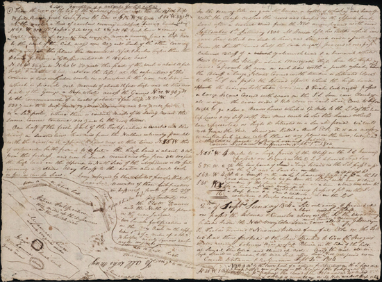
(1) From the river on the top of the antient fortification at this the 12 foot high 75 feet Base first Corse is from the river is S 76° W 96 yards. S 84° W 53 yds. at this angle a kind of ravilene [ravelin] covering a Sale-port [sallyport], bearing East widing N 69 W 300 yds. passed a gate way at 280 yds. the bank lower & forming a right angle of 30 yards— two wings or mounds running from a high nold to the West of the [Call?] way one 30 yards back of the other Covering the gate (at this place the mound is 15 feet 8 Inches higher than the plain forming a Glassee [glacis] outwards & 105 feet base N. 32 W. 56 yards N. 20 W. 73 yards this part of the work is about 12 feet high, leavel & about 16 feet wide on the top) at the experation of this course a low irregular work in a Direction to the river, out Side of which is several ovel mounds of about 16 feet high and at the iner part of the Gouge [gorge] a Deep whole across the Gauge N. 32 W 96 yds. to the Commencment of a wall of about 8 feet high N. 81 W. 533 yards to a Deep pond 73 yds in Deamuter, and 200 yards further to a Saleport, where there is evident marks of its being Covered, the Same Course Contined 1030 yards to the river bottom.
ca. September 2, 1804, Field Notes, document 51
One half of the first part of the Fortification is washed into the river, a Second line, has run from the Northrn extremity parrelel with the river (as it appears to have run at that time[)] N. 56 W. this of different hith from 4 to to 10 feet— The high land is about 3 me. from this fortress, and rise to Small mountains Say from 3 to 400 feet the high land on the opposit or North Side of the Missourie is 110 feet forming a yellow Clay bluff to the water and is leavel back as fur as can be Seen. I am informed by the inteperter & french, that they have Seen, numbers of those fortifications in different parts of this Cty. pirtcularly on the Platt Kansies and the North of this place on the river Jacque.
two Small fortifications is on the Arc Creek on the upper side 1st ¼ of a mile up & the 2d ¼ higher, nearly Square each angle 100 yards
[Clark]
Set out early and proceeded on Passed the Island and Landed on the S. S above under a yellow Clay bluff of 110 feet high, the wind blew verry hard a head from the N. W. with Some rain and verry Cold, G. Drewnyer R. Fields Newman & howard Killed four fine Elk w[e] had the meat all jurked and the Skins Dried to Cover the Perogue, on the Side of the Bluff I observed Bear Grass & Rhue, at Sun Set the wind luled and Cleared up Cold, the high land on the L. S. is verry high, & uneaven, that on the S. S from so to 120 foot & is leavel back but fiew Small Streems falling into the river.
| N. 75° W. | 3 | mes. to the lower part of an antient fortification (1) in a bend to the L. S. this Course passed ovr a pt. of the Isd & Sand |
| N. 45 W. | 1 | me. on the L pt. passed the head of the Island at ¾ of a mile opsd. a yellow bank S S. |
| 4 |
I went out and made a Survey of the antient works which is Situated in a level plain about 3 miles from the hills which are high.
| S. 76d W. | 96 | yards thence |
| S. 84 W. | 53 | yards (at this angle a kind of angle or horn work[)] |
| N. 69 W. | 300 | yards to a high part, passing the gateway Covered by two half Circler works one back of the other lower than the main work the gate forms a right angle projecting inward |
| N. 32 W. | 56 | yards |
| N 20 W. | 73 | yards This part of the work appears to have either double, or a covered way. from this Some irregular works appear to have been on mounds between this and the river with a Deep round whole in the center of a gorge formed by another angle |
| (578) |
This part of the work is from 10 to 15 feet 8 Inches— the mounds of various hights— the base of the work is from 75 to 105 feet, steep inward and forming a kind of Glassee out wards—
the Same Cours continued i e
| N. 32° W. | 96 | yards to, the Commencement of a wall from 8 to 10 feet high this corse not on the wall but thro to the commenc- ment of another detached |
| N. 81° W | 1830 | yards to the river & above where this bank Strikes the river is the remains of a Circular work |
in this Course at 533 yards a Deep Pond of 73 yards Diameter perfectly round is in the Course of the bank which is about 8 feet high, from this Pond the bank it lowers gradually— a bank about the Same hight runs near the river, and must have joined the main work at a part which is now washed into the river, this is also perfectly Streight and widens from the main work, as the river above has washed in its banks for A great distance I cannot form an Idear How those two long works joined— where they Strike the river above, they are about 1100 yds apart, I am informed by our freench interpeters that a great number of those antint works are in Different parts of this Countrey, on the Platt River, Kansus, Jacque, Osarge Mine river &c.
〈the〉 Small one is on Island opposit the one I have Discribed, and two of our Party Saw two of those antient frtresses on the Pittiet Arc Creek on the upper Side near the mouth, [4] each angle of which were 100 yards and about 8 feet high—
[Ordway]
Sunday 2nd Sept. 1804. a hard Storm arose the latter part of last night ½ past 1 oC. of wind & rain from N. W. which lasted abt. 2 hours. Cloudy this morning we Set off eairly. Sailed a Short distance with a S. E. wind & in less than 2 hours the wind Shifted in to the N. W. which Blew hard a head, G. Drewyer R. Fields & Collins out hunting this morning on N. S. as we passed or passing a prarie on S. S. we heard Several guns fire which we Supposed to be our hunters. directly we heard them hollow from the Island for help to bring in their Game, R. Fields killed one Buck Elk, and Drewyer killed 2 Elk & Newman & Howard killed one on the opposite Shore; we halted to take Breakfast at 8 o.C. at the Bottom prarie, where their was an ancient fort. [5] the Entrenchment which formed a Circle from the river in the form of a half moon, at the lower pt. End Capt. Clark went on Shore with the compass in order to find the angles &.C. the Boats went on to the head of Elk or Bon hommen Isd. Island, the wind Shifted into the North & Blew So heard that we were obledged to lay by at 〈the〉 a high Bluff, abo. Elk or Bon hommen [6] Isl. handsome high praries back from the river, we found plumb orchads on a Spring run & an amence Site of Grapes as before, we Scarcely passed a day as yet on the Missouri, in the time or Season of them but what we found them in great abundance &.C. the weather is Cool & rainy to day Capt. Clark returned to the Boat, & Informed us that had been a large ancient fortification made their. Some places remains yet 5 feet high & on one Side of it is nearly Strait across the point & strikes the river, & is more than a mile & half in length & So ancient that Some Trees Stands on the works &.C. considerable of cottonwood Timber on the Upper part of this point back from the river is Broken Barron hills which are verry high & Sandy &.C.
[Gass]
Sunday 2nd. At 1 o'clock last night we had hard thunder, lightning and rain, which continued about two hours. We set out early in the morning, along the north side of the island: there is handsome prairie land on the south. Three of our men [7] went on the island to hunt. When we landed for breakfast, we heard several guns fired on the island, and saw six elk swimming across the river about a mile above where we had halted. Two of our men went up and killed one of them; those on the island killed three. [8] About twelve, the wind blew so hard down the river, that we could not proceed, and we landed on the north side, where there is an extensive prairie. It was cloudy and rained till 4 when it cleared up. We remained here for the night and dried our meat. On the bank opposite our camp is an ancient fortification or breastwork, [9] similar to those which have been occasionally discovered on the western waters. The two ends run at right angles to the river, and the outside, which is 2500 yards in length, parallel to it: there is no breastwork thrown up next to the river, the bank as is supposed, serving as a sufficient defence on that side. [10]
[Whitehouse]
Sunday 2nd Sept. 1804. a hard Storm of wind and rain last night which lasted about 2 hours, cloudy this morning we Set off eairly three men out hunting. the hunters killed three Elk. we halted at 8 oC on the S. S. where their was an ancient fortification in the form of a half moon [11] it appeared that one Side had washed into the river. Capt. Clark took the dimentions of it. the wind high from the North So that we were oblidged to lay too at a high prarie where we found plumbs & Grapes [12] a pleanty—
Sunday September 2nd Last night we had a hard Storm of Wind, accompanied with Rain, which was very heavy. it lasted for near 2 hours we set off early this morning having cloudy weather, Three of our Men went a hunting & Return'd to us, having killed 3 Elk, which they brought to us.—
We came too with our boat at 8 o'Clock A. M. on the South side of the River, near where the remains of an Ancient fortification stood, it was in the form of a half Moon, and had the appearance of once being very Strong, One side of it had washed into the River. Captain Clark took the dimensions of it being 1¾ Miles in length 600 Yards wide in the Center.— The wind raising & blowing hard from the North, we proceeded on but a small distance, and came too at a high Priari, where we found Plumbs & Grapes in great abundance
"ravilene"— a ravelin is a detached work of two lines forming an angle in front of the main fortification.
"Saleport"— a sallyport is an opening through which the defenders could make a sally, that is, a small, quick attack, and then retreat.
"Glassee"— a glacis is a natural or artificial slope in front of a fortification, on which the attackers would be exposed to fire from the defenders.
"gouge"— a gorge is the entrance into some outlying work.
"horn work"— a type of detached work joined to the main fortification by parallel walls. (back)

