July 3, 1806
[Lewis]
| Courses and distances from travellers rest. | ||
| North | 7 | m. to the crossing of Clarke's river, [2] valley wide tops of the hills covered with Long leaf pine. bottoms pine and Cottonwood. passed a small branch at 3 M on W. side and at 1 M. further the entrance of a small creek on E. side. [3] at 5 miles Co-kâh-lâr coosh or buffaloe river falls in on the East side. [4] Clark river 120 yds. wide buffaloe river [blank] yard wide— set out at 8 A. M. halted at 11 A M. to make a raft. dined here. |
| N. 75 E | 7 | m. through a handsome level plain to the point where the Cokahlar ishkit River enters the mountains, or where the hills close it in on both sides. we halted 〈one〉 five mile short of this place on a little stream 〈which runs down from the 2nd largest of the rivers〉 [X: nothern] we encamped. [5] Sent out the hunters they killed three deer gave the indians half. the musqutoes troublesome built fires for our horses. [6] we did not get over the river until 6 P. M. I fell in the water and wet the chronome- ter. we made three rafts. indians express great ap- prehension with rispect to the Minetares. saw the fresh track of a horse in the main road which leads up this river which the indians supposed to be the Shalees. Took leave of Capt. C. and party to-day. gave one of my shirts and a handkercheif to the two Indians whom we met on Collin's Creek and detained some [days?] |
[Lewis]
All arrangements being now compleated for carrying into effect the several scheemes we had planed for execution on our return, we saddled our horses and set out I took leave of my worthy friend and companion Capt. Clark and the party that accompanyed him. I could not avoid feeling much concern on this occasion although I hoped this seperation was only momentary. I proceeded down Clark's river seven miles with my party of nine men and five indians. [7] here the Indians recommended our passing the river which was rapid and 150 yds. wide. 2 miles above this place I passed the entrance of the East branch of Clark's River which discharges itself by two channels; the water of this river is more terbid than the main stream and is from 90 to 120 yds. wide. as we had no other means of passing the river we busied ourselves collecting dry timber for the purpose of constructing rafts; timber being scarce we found considerable difficulty in procuring as much as made three small rafts. we arrived at 11 A. M. and had our rafts completed by 3 P. M. when we dined and began to take over our baggage which we effected in the course of 3 hours the rafts being obliged to return several times. the Indians swam over their horses and drew over their baggage in little basons of deer skins which they constructed in a very few minutes for that purpose. [8] we drove our horses in after them and they followed to the opposite shore. I remained myself with two men who could scarcely swim untill the last; by this time the raft by passing so frequently had fallen a considerable distance down the river to a rapid and difficult part of it crouded with several small Islands and willow bars which were now overflown; with these men I set out on the raft and was soon hurried down with the current a mile and a half before we made shore, on our approach to the shore the raft sunk and I was drawn off the raft by a bush and swam on shore the two men remained on the raft and fortunately effected a landing at some little distance below. I wet the chronometer by this accedent which I had placed in my fob as I conceived for greater security. I now joined the party and we proceeded with the indians about 3 Ms. to a small Creek and encamped at sunset. I sent out the hunters who soon returned with three very fine deer of which I gave the indians half These people now informed me that the road which they shewed me at no great distance from our Camp would lead us up the East branch of Clark's river and a river they called Cokahlarishkit or the river of the road to buffaloe [9] and thence to medicine river [10] and the falls of the Missouri where we wished to go. they alledged that as the road was a well beaten track we could not now miss our way and as they were affraid of meeting with their enimies the Minnetares they could not think of continuing with us any longer, that they wished now to proceed down Clark's river in surch of their friends the Shalees. they informed us that not far from the dividing ridge between the waters of this and the Missouri rivers [11] the roads forked they recommended the left hand as the best rout but said they would both lead us to the falls of the Missouri. I directed the hunters to turn out early in the morning and indeavour to kill some more meat for these people whom I was unwilling to leave without giving them a good supply of provision after their having been so obliging as to conduct us through those tremendious mountains. the musquetoes were so excessively troublesome this evening that we were obliged to kindle large fires for our horses these insects tortured them in such manner untill they placed themselves in the smoke of the fires that I realy thought they would become frantic. about an hour after dark the air become so coald that the musquetoes disappeared.
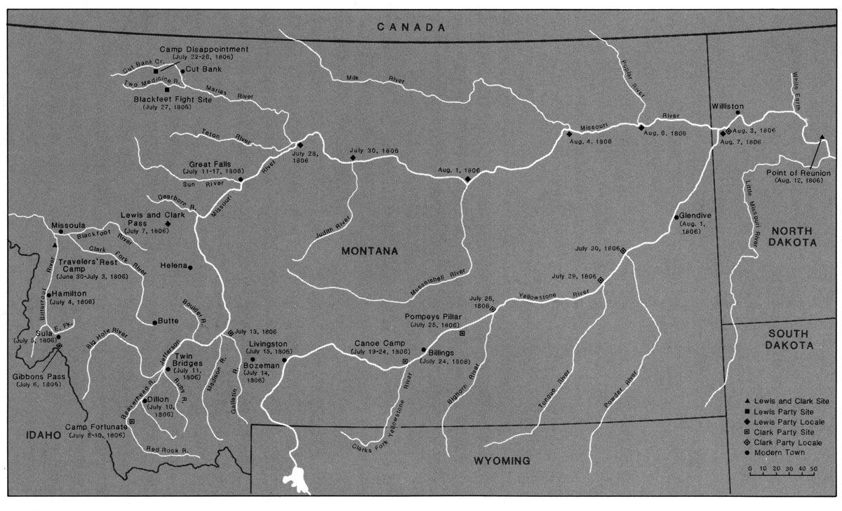
| North— | 7 | M. down the West side of Clark's river to the place at which we passed it. forded travelers rest C. ½ a mile below our camp, passed a branch on west side at 2½ m. further also at 1 m. further passed the entrance of a small creek on the E. side of Clark's river, and two miles short of the extremity of the course passed the entrance of the East branch of Clark's river which discharges itself in two channels. Clark's river 150 yds. wide the East branch from 90 to 120. the vally of Clarks river is extensive beatifull level plains and praries. the tops of the hills and mountains on either hand are covered with long leafed pine larch and fir; near the river the bottoms are timbered with long leafed pine and cottonwood. |
| N. 75 E. | 7 | M. through a handsom leve plain to the point at which the East branch enters the mountains or where the hills set in near it on either side. we halted and encamped on a small creek 5 miles short of the extremity of this course. a Creek 15 yds. wide falls into the E. branch on it's N. side one mile short of the mountain. [12] |
| ms. | 14 |
We saw the fresh track of a horse this evening in the road near our camp which the indians supposed to be a Shale spye. [13] we killed a prarie hen with the short and pointed tail she had a number of young which could just fly.
[Clark]
we colected our horses and after brackfast I took My leave of Capt Lewis and the indians and at 8 A M Set out with [blank] men [14] interpreter Shabono & his wife & child (as an interpreter & interpretess for the Crow Inds [15] and the latter for the Shoshoni) with 50 [16] horses. we proceeded on through the Vally of Clarks river [17] on the West Side of the [river] nearly South 18 [13?] Miles and halted on the upper Side of a large Creek, haveing Crossed 8 Streams 4 of which were Small. this vally is from 10 to 15 Ms. in width tolerably leavel and partially timberd with long leaf & pitch pine, [18] Some cotton wood, Birch, [19] and Sweet willow [20] on the borders of the Streams. I observed 2 Species of Clover [21] in this vally one the white Clover Common in the Western parts of the U. States, the other Species which is much Smaller than either the red or white both it's leaf & blossom the horses are excessively fond of this Species. after letting our horses graze a Sufficient length of time to fill themselves, and taking dinner of Venison we again resumed our journey up the Vally which we found more boutifully versified with Small open plains covered with a great variety of Sweet cented plants, flowers & grass. this evening we Crossed 10 Streams 8 of which were large Creeks [22] which comes roleing their Currents with Velocity into the river. those Creeks take their rise in the mountains to the West [23] which mountains is at this time Covered with Snow for about 1/5 of the way from their tops downwards. Some Snow is also to be Seen on the high points and hollows of the Mountains to the East of us. [24] our Course this evening was nearly South 18 Ms. making a total of 36 miles today. we encamped on the N. Side of a large Creek [25] where we found tolerable food for our horses. Labeish killed a Deer this evening. We Saw great numbers of deer and 1 bear today. I also observed the burring Squirel of the Species Common about the quawmarsh flatts West of the Rocky Mountains. [26] Musquetors very trobulesom.— one man Jo: Potts very unwell this evening owing to rideing a hard trotting horse; I give him a pill of Opiom which Soon releve him.
[Ordway]
Thursday 3rd 1806 July. we got up our horses and boath parties Set out about one time. Capts. Lewis & Clark parted here with their parties & proceed. on I with Capt. Clark up the flat head River. [27] we kept up the west Side as it is too high at this time to cross. we are now on our way to the head of the Missourie. we wrode fast & Crossed a number of large creeks in which is beaver dams &C. about noon we halted to dine at a branch [28] and bottom of fine feed white clover [29] &C. proceeded on the plains partly covd. with pitch pine timber. Saw a number of deer. in the evening we Camped [30] at a bottom having made 35 miles in 10 hours this day. one of the hunters killed a deer this evening.
[Gass]
Thursday 3rd. We had again a fine morning; collected our horses and set out. Captain Lewis and his party [31] went down Clarke's river, and Captain Clarke with the rest of the party went up it. All the natives accompanied Captain Lewis. We proceeded on down Clarke's river about 12 miles, when we came to the forks; [32] and made three rafts to carry ourselves and baggage over. The river here is about 150 yards wide, and very beautiful. We had to make three trips with our rafts, and in the evening got all over safe; when we moved on up the north branch, which is our way over to the falls of the Missouri, and, after travelling a mile and a half encamped [33] for the night. Two hunters went out and killed three deer. The musketoes are worse here than I have known them at any place, since we left the old Maha village on the Missouri. [34] This north branch of the river is called by the natives Isquet-co-qual-la, [35] which means the road to the buffaloe. [36]

