Part 1: Estimated Distances from Fort Mandan to the Pacific Coast
Winter 1805-1806
Clark prepared this extensive list of estimated distances for the route from Fort Mandan to the Pacific Coast as an apparent supplement to his route maps. This document is found in Codex I, pp. 2–12, apparently wholly in Clark's hand. Two other versions of this table exist. One is in the little field book with Clark's draft of his trip to the coast, January 6–10, 1806, and the other is in Voorhis No. 4. The one in the draft notebook is labeled, "Distances of the Mouthes of Rivers Creeks and the Most remarkable places from Fort Mandan & Lattiduds in 1805." It does not have the remarks that are found in the final column of the Codex I and Voorhis versions. The title for the Voorhis table is quite similar to the codex piece, with only some spelling differences and minor word changes. The tables in the draft and Voorhis notebooks have been compared to the one printed below. From the start the mileage figures from point-to-point and the accumulated mileage are in disagreement. The draft version appears at first to have been just that for Codex I, but later it digresses while the codex and Voorhis items more regularly agree with one another, eventually the draft version exceeds the other tables by four miles in the accumulated mileage column and remains so to the end. The codex and Voorhis notebooks vary by up to nine miles in early entries. There are few dissimilarities for the latitudes between the three versions, while the column of remarks in the codex and Voorhis documents differ only slightly in wording. Another partial version of a similar table exists in microform and photostatic copies at the University of Virginia, Charlottesville, and the National Archives, Washington, D.C. (see Appendix C). That table lists geographic points from the mouth of the Missouri River to the Great Falls of the Missouri, together with mileage figures and occasional latitude readings. Here again there are discrepancies with other tables but mainly in terms of minor mileage differences. All of this material was eventually gathered with similar tables from Codex C and other documents (see Chapter 10) including information from the return journey and made into one comprehensive table for the entire trip and placed in Codex N and Voorhis No. 4. That table will appear in volume 8 of this edition. Clark had, of course, kept all these distances and other data carefully in his journals, and at Fort Clatsop he apparently brought them together in several versions. Unlike the record of streams and distances prepared at Fort Mandan (see Chapter 10), this compendium covers territory almost entirely unexplored previously by whites, which made it all the more significant. It also includes the names of the Indian tribes the party encountered and some explanations of names they bestowed on streams. The Indians are covered more fully in the next part of this chapter.
[Clark]
Estimated Distances in Miles Ascending the Missouri, Crossing the Rockey Mountains & decending the Kooskooskee, Louises River and the Columbia River of the remarkable places and Latitud partially anexed.
|
Names of remarkable places |
from one place to another |
Distanc to the mouth of Missourie |
Latitude & remarks &c. |
||
| From Fort Mandan | — | 1600 | 47° 21 47" N. | ||
| To Knife River on the Lard. side 100 yds. wide |
6 |
1606 |
Mi-ne-ta-reis live |
||
| To an Island near the Std. | 11 | 1617 | small | ||
| To a Menatarras Wintering Village S |
13 ½ |
1640 ½ |
abandoned |
||
| To Miry River on the Std. | 2 ¼ | 1642 ¾ | bold | ||
| To an Island in the little bason |
28 |
1670 ¾ |
small |
||
| To the mo. of Little Missouri
Lard. 134 |
29 |
1699 ¾ |
47° 31' 26.2" N. |
||
| To Wild Onion Creek Std. 16 | 12 ½ | 1712 ¾ | a little water | ||
| To Goose eggs Lake run Std. | 9 ¼ | 1722 | Small | ||
| To Shabonoes Creek Lard. 20 |
16 |
1738 |
47° 47' 168/10" N. |
||
| To the Goat pen Creek Std. 20 |
15 |
1753 |
〈47 42 16 8/10〉 North near Mouse river |
||
| To Hall's Strand Lake
& Creek Std. |
40 |
1793 |
extream N. point |
||
| To White earth River Std. 60 | 46 | 1839 | Still & deep | ||
|
Rojhone or Yellow Stone
River Ld. 858 |
48 |
1885 |
48° 00' 00" N. |
||
| To Marthys River Std. 50 | 57 | 1944 | High coloured | ||
| To Porcupine River Std. 112 | 53 | 1997 | Som timber on it | ||
| To 2000 mile Creek Lard. 30 | 3 | 2000 | no water at prst. | ||
| To Indian Fort Creek Ld. dry |
10 |
2010 |
a fort of logs |
||
| To Little dry Creek Ld. 25 | 27 | 2037 | no water in it | ||
| To Lackwater Creek Std. Ld. 25 |
1 ½ |
2038 ½ |
do do do | ||
| To Big Dry Creek Ld. 100 | 7 ½ | 2046 | do do do | ||
| To Little Dry River Ld. 200 | 5 | 2051 | do do do | ||
| To the Gulph in bend to the Stard. |
30 |
2081 |
47° 36' 11" |
||
| To Milk River on the Std. 150 |
13 |
2094 |
Color of tea |
||
| To Big Dry Run dry Ld. 400 | 25 | 2119 | no water runing | ||
| to Warners run or Creek Std. | 9 | 2128 | 47° 25' 33 1/10" | ||
| to Pine Creek Std. 20 | 33 | 2161 | Saw 1st pine | ||
| to Gibsons Creek Std. 35 | 16 | 2177 | a little running water | ||
| to Brown Bear defeated Creek Ld. 40 |
12 |
2189 |
do do do |
||
| to Brattins River Std. 100 | 24 | 2213 | 47° 13' 51" N. | ||
| to Burnt lodge Creek Ld. 50 | 6 | 2219 | no water running | ||
| to Wisers Creek Std. 40 | 14 | 2233 | a little running W. | ||
| to Blowing fly Creek Lard. 25 |
32 |
2265 |
do do do |
||
| to Muscle Shell River Ld. 110 |
5 |
2270 |
47° 0 24 6/10" N. |
||
| to Grouse Creek Std. | 30 | 2300 | no running water | ||
| to Tea pot Creek Std. 15 | 8 | 2308 | do do do | ||
| to North Mountain C: Std. 30 |
28 |
2336 |
running water |
||
| to South Mountain Creek
Ld. 30 |
18 |
2354 |
do do |
||
| to Ibex Island | 15 | 2369 | Killed a big horn | ||
| to Goodrich's Island | 9 | 2378 | |||
| to Windsers Creek Std. 30 | 7 | 2385 | Some water runs | ||
| to Sofshell turtle Creek Std 25 |
6 |
2391 |
do do do |
||
| to Elk rapid | 9 | 2400 | Doe Elk & faun Swam over |
||
| to Thompsons Creek Std. 28 | 27 ½ | 2427 ½ | { | vally above Mts. | |
| bold stream | |||||
| to Bull Creek Ld. 25 | 8 ½ | 2436 | { | a Buffalow crossed | |
| a canoe & tho' C | |||||
| to Big horn River Ld. 100 | 3 | 2439 | Killed 3 big horns | ||
| to Vally Creek Std. 20 | 1 | 2440 | thro a Vally N. | ||
| to Ash rapid | 3 | 2443 | Some ash trees | ||
| to the Slaughter River
Lad. 40 |
11 | 2454 | { | a great no. of buffalow | |
| drove down a Clift and | |||||
| dashed to picies on | |||||
| Std. I speared a wolf | |||||
| to Stone wall Creek Std. 30 | 26 | 2480 | { | Curious appearance of | |
| walls below | |||||
| to Marias River Std. 186 | 41 | 2521 | 47° 25' 17 3/10 N. | ||
| to Snow River Ld. 50 | 19 | 2540 | Mtn Covd. with Snow head of this river |
||
| to Shields River Ld. 35 [2] | 28 | 2568 | bold Stream | ||
| to the foot of the great | } | 7 | 2575 | 47° 8' 4 9/10" N | |
| rapids at a the great | |||||
| portage Lard. sd. | |||||
| to Portage River Lard. Side 55 |
1 |
2576 |
rapid & Sholey |
||
| to the first great fall of 87 feet pitch |
6 |
2582 |
Continual Spray |
||
| to the Second fall of 19 feet pitch |
3 ½ |
☞ 1718 poles |
|||
| to the Grand Cascade of 47 feet 8 In pitch |
½ |
102 poles |
|||
| to the upper fall of 26.5 | } | 2 ¾ | 2590 ½ | 881 poles | |
| pitch total fall above | |||||
| portg. about 362 feet | |||||
| to Medicine River Std. 137 | 3 ¾ | 2594 ¼ | 1196 poles | ||
| to the head of the Portage | } | 3 | 2586 ¼ | 972 poles 47° 3' 33" N. |
|
| on the Ld. at the white Bear | |||||
| Islands, the land portage | |||||
| 18 miles thro: a plain | |||||
| to Smith's River Lard. 80 | 30 ¾ | 2628 | bold current & Vally | ||
| to the Rockey Mountains at Pine Island rapid |
40 ¼ |
2668 ¼ |
46° 42' 14 7/10" |
||
| to Dearbourne's River Std. 80 | 8 ¾ | 2676 | bold current & in Mtn. | ||
| to Gun brook Ld. 10 | 2 | 2678 | found a fusee | ||
| to Ordways' Creek Std. 25 | 10 | 2688 | bold current Vly | ||
| to the Great gate of the rock | } | 24 | 2712 | W. Clark across Sd. mtn. | |
| Mounts. river confined in | |||||
| a narrow channel between | |||||
| Clifts of 1200 feet high | |||||
| to Pott's Vally Creek Std. bold | 6 | 2718 | { | [illegible, erased] | |
| Wide vally N. | |||||
| to Pryors Vally River
Std. 28 yds |
20 | 2738 | { | Ltd 46° 10' 32 9/10" N bold | |
| Current and wide extence | |||||
| Vally saw a smoke N W | |||||
| to White Earth Creek Std. [3]
bold |
30 |
2768 |
bold 15 |
||
| to White House Creek Lad bold |
11 |
2779 |
Some timber on it 15 |
||
| to Yorks 8 Islands | 23 | 2802 | W C on land York tired | ||
| to Gasses Vally Creek Std. 25 | 14 | 2816 | bold & 3 forks & | ||
| to the Little Gate of the Mountain |
5 |
2821 |
we saw a horse |
||
| to Howards Creek Lard. bold | 6 | 2827 | { | mistook the Spring of the | |
| Creaf for the [illegible] | |||||
| to the three forks of Missouri | } | 21 | 2848 | W. C. return to the party verrry sick 45° 22' 34" N |
|
| at Jefferson, Madderson & | |||||
| Gallitins rivers. Gallintins | |||||
| on Ld. and 70 yds wide Mad- | |||||
| dison 90 yds wide & Jeffer- | |||||
| sons 90 yds wide and is the | |||||
| Std. fork | |||||
|
Up Jeffersons River
to Philosophy River on Ld. Side 30 |
15 |
2863 |
bold rapid |
||
| to the Narrows of the 3d Mountn. |
17 |
2880 |
M. L. go a head |
||
| to Frazures Creek & rapid Ld. bold |
8 |
2888 |
bad rapid |
||
| to R. Field's Vally Creek Sd. 28 |
4 |
2892 |
R. F. killed 4 deer |
||
| to Wisdom River Std. Side 40 | 55 | 2947 | 45° 2' 21 6/10" N | ||
| to Philanthrophy River Ld. 30 |
12 |
2959 |
river crooked |
||
| to Beaverhead Clifts Stad. Side |
34 |
2993 |
do. do. |
||
| to McNeals Creak Ld. bold |
37 |
3030 |
bold Stream 17 |
||
| to the 4th Gap of the Mountain |
28 | 3058 | { | Saw Several rattle | |
| snakes | |||||
| to Willards Creek Std. bold | 6 | 3064 | { | Willard discovered this the | |
| day before we got to it | |||||
| to a rapid at the narrows of | } | 21 | 3085 | { | a bad rapid for half a mile |
| 5th Mtn. | |||||
| to the East fork of Jeffersons | } | 11 | 3096 | 44° 35' 28 1/10" | |
| river at which place left the | |||||
| Canoes and Commened a | |||||
| portage | |||||
| to the 3 forks in Snake In-
dian vally |
15 |
3111 |
W C. Camp with Inds. |
||
| to the head Spring of Jeffer- | } | 13 | 3124 | meet an Ind. on a Mule | |
| sons river in a Dividing ridge | |||||
| of the rock M | |||||
| to the snake Indian or So-so- | } | 10 | 3134 | 44° 23' 22 7/10" | |
| nee Nation on the East fork | |||||
| of Louieses River one of the | |||||
| Easterly forks of the great | |||||
| Columbia river from S. E. & | |||||
| 35 yds. | |||||
| to the main fork of Louises River Ld 90 |
18 |
3152 |
from the South |
||
| to Salmon Creek Std. Side bold |
9 |
3161 |
Shields killed a fish |
||
| to tower run Std. Small | 14 | 3175 | leave Lowis's river | ||
| up tower run to the forks of the road |
4 |
3179 |
road leave the river |
||
| Across the hills. To fish |
} | 20 | 3199 | hilly road | |
| Creek six miles north of its | |||||
| mouth. 25 | |||||
| to the forks of the road & Creek |
7 ½ |
3206 ½ |
cross the C. often |
||
| to the Top of a Snow Moun- | } | 21 ½ | 3228 | pilot lost to the right | |
| tain at the head of the Creek | |||||
| to Clark's River [4] at a village | } | 12 | 3240 | river from right | |
| of 33 tents of Flathead | |||||
|
Down Clarks' River
to flour Camp Creek Ld. bold |
7 |
3247 |
over a mountn. |
||
| to Horse Vally Creek
[5] in Horse Vally |
26 |
3273 |
bold Stream Sd. |
||
| to Scattered Creek do. Sd. | 22 | 3295 | 46° 41' 38.9" | ||
| to Travellers rest Creek Ld. 30 |
21 |
3316 |
46° 48' 28 8/10" |
||
| Commencement of high hills up Travellers rest creek [6] | |||||
| to the forks of the road and Creek Sd. |
11 |
3327 |
road to our right |
||
| to the Hot Springs on the right |
14 |
3341 |
nearly boiling |
||
| to the Glades on the Divinding Mtn. |
10 |
3351 |
|||
| to the forks of Glade Creek | 6 | 3357 | crossed to S E. side | ||
| to Koos-koos-ke river mo: Glade C: |
9 |
3366 |
Killed a coalt |
||
| to the foot of the Great Mountains |
6 |
3372 |
open pine Countrey |
||
| 56 | |||||
| Across the Great Rocky Mountains [7] | |||||
| to the top of a mountain Cov- | } | 8 | Snow high rugid | ||
| ered with Snow the 15th of | |||||
| Septr. the forks of the road | |||||
| from our right | |||||
| to a branch running to the right on M |
13 | { | do do do |
||
| Eat a Coalt | |||||
| to a branch running to the left on M. |
10 | { | do do do |
||
| Eat a Coalt | |||||
| to Hungry Creek on the left on M |
32 | { | do do do |
||
| Killed a Horse | |||||
| to the forks of Collinses
Creek large |
26 |
do do |
|||
| to the foot of the Mountain west |
8 |
3469 |
open pine Country |
||
| 97 | |||||
| to the
Cho pun-nish (Flathead
) Villages |
6 |
Seatd. in a prarie |
|||
| to Koos-kooske River at the | } | 17 | about 120 yds wide | ||
| mouth of village Creek from | |||||
| the right | |||||
| to Rock dam Creek Stard. 20 yds. |
3 |
damed by rocks |
|||
| to Cho-pun-nish River from | } | 5 | 3500 | 46° 34' 56 2/10" N. | |
| the N. E. (at Canoe Camp) | |||||
| 120 | |||||
| to Canister run Ld. (passd. 16 rapids) |
19 |
passed 16 rapids |
|||
| to Colters Creek Std. (psd. 14 rapids) 20 |
18 |
passed 14 rapids |
|||
| to Lowises river at the mouth | } | 23 | 3560 | 46° 29' 21 7/10" N. | |
| of the Kooskooske river | |||||
| to the Swet house Village on Ld. |
7 |
3567 |
Passed 1 rapid |
||
| to the Pilots Village on the Stard |
11 |
3578 |
passed 4 rapids |
||
| to a village of Mat Lodges Std. |
13 |
3591 |
" 3 " |
||
| to Ki-moo-ê-nim Creek Ld. 20 | 35 | 3626 | " 8 " | ||
| to Drewyers River on the Std | } | 5 | 3631 | " 1 " | |
| Side below the narrows of | |||||
| 2 ½ 30 | |||||
| to the Cave rapid, a Canoe | } | 28 | 3659 | " 5 " | |
| Sunk at this rapid | |||||
| to the bason rapid (bad) | 34 | 3693 | " 8 " | ||
| to the Discharge [8] rapid (bad) | 14 | 3707 | " 4 " | ||
| to the
Columbia
at the mouth of Lewis's River (on its Lard Side) |
7 |
3714 |
" 1 " 46° 15' 13.9" |
||
| to a Village of 9 Mat Lodges | } | 9 | 3723 | above a bad rapd. | |
| of the So-kulk nation on the | |||||
| 4th Island | |||||
| to 2 Lodges at the foot of a bad rapid |
3 |
3726 |
a rapid |
||
| to Wal-ler wal ler river S. S. 40 | } | 4 | 3730 | hills about 200 feet | |
| yds [9] river enters range of | |||||
| high land | |||||
| to Yel-lep-pets Village of 16 | } | 4 | 3734 | passed 1 rapid | |
| mat Lodges of the 〈Sokulk〉 | |||||
| nation Sd. | |||||
| to the lower of 17 Lodges on | } | 15 | 3749 | " 1 " | |
| three Islands opposit the hat | |||||
| rock Ld. | |||||
| to the Muscle Shell rapids
(bad) |
6 |
3755 |
Low Cty. comns. Ld. |
||
| to the upper Lodges of the | } | 3 | 3758 | ||
| fritened band of Pish quit | |||||
| pahs [10] nation on the | { | low Country on | |||
| Std. Side Comencement of | both Sides of R | ||||
| the low countrey on either | |||||
| side | |||||
| to Pelican rapid at the lower | } | 19 | 3777 | ||
| of 48 Lodges of the fritened | { | low Countrey on both | |||
| band scattered on the Std. | Sides of R | ||||
| shore | |||||
| to the Commencement of the | } | 18 | 3795 | passed 2 rapids | |
| high lands on the Std. Side at | |||||
| the lowest of 21 Lodges of | |||||
| Wah-how pums [11] nation on 4 | |||||
| Islands (horse scerfised to the | |||||
| Dead) | |||||
| to the Commencement of the | } | 16 | 3811 | " 1 " | |
| high land on the Lard Side at | |||||
| a rapid | |||||
| to a rapid at 8 Lodges of the | } | 9 | 3820 | " 1 " | |
| Sd. side of the Wah how | |||||
| pums [12] nations— | |||||
| to the Short rapid | 6 | 3826 | " 1 " | ||
| to 9 Mat Lodges at the rockey rapd. |
7 |
3833 |
" 1 " |
||
| to River la page on the Lard | } | 9 | 3842 | " 2 " | |
| Side at a bad rapid 40 yds. | |||||
| to the lower of 16 mat | } | 4 | 3846 | Campd. 1 " | |
| Lodges of the E-nee-sher | |||||
| Nation on Std. | |||||
| to 11 Lodges of the E-nee- | } | 6 | 3852 | " 2 " | |
| sher Nation at fish Stacked | |||||
| rapid | |||||
| to the Towahnahiooks [13] | } | 8 | 3860 | we all viewed it above its mouth |
|
| River from the Lard Side | |||||
| 180 yd | |||||
| to the Falls of the Columbia | } | 4 | 3864 | 45° 42' 57 3/10" | |
| of 37 feet 8 ins near which is | |||||
| 40 Mat Lodges of the E-Nee- | |||||
| sher Nation | |||||
| to the Short Narrows of 45 yds. wide |
2 |
" 1 " |
|||
| to the E che lute Town of 21 | } | 4 | 3870 | 45 I " | |
| large wood houses at the | |||||
| long narrows of from 50 to | |||||
| 100 yds wide | |||||
| to a Chil luck it te quaw town | } | 14 | 3884 | bought Dogs | |
| of 8 houses on the Stard. | |||||
| side. | |||||
| to the friendly village of 7 | } | 6 | 3890 | resd. of Chiefs | |
| wood houses of the Chilluck | |||||
| it le quaw N. | |||||
| to the mouth of Cataract | } | 4 | 3894 | ||
| River on the Std. Side of | { | 10 Nations live up this | |||
| 60 yds wide at 11 houses | river. no fish | ||||
| of the Chilluckittequaw | |||||
| to River Labeach on the Ld. | } | 13 | 3907 | ||
| 40 yds. at a village of 26 | |||||
| houses scattered on each side | { | the first houses we have | |||
| of the river of the Smack shop | seen on the south side | ||||
| Nation [14] | |||||
| to Canoe Creek on the Std. 28 |
1 |
3908 |
Saw Several Canoes |
||
| to 3 houses of
Smack shop
Ntn. Std. |
9 |
3917 |
Encamped |
||
| to Cruzatt's River Std. 60 yds. | 12 | 3929 | { | Stumps out from shore | |
| some diste. | |||||
| to the Great Rapids near a | } | 6 | 3935 | 45° 44' 3 8/10" | |
| Village of 8 large wod houses | |||||
| on the Stard. Side above of | |||||
| the Sha ha lah Nation | |||||
| to a village below the great | } | 1 | 3936 | not inhabited. | |
| rapids of 4 houses aban- | |||||
| daned opsd. a 2d bad rapid | |||||
| to 4 houses of the Sha ha lah | } | 6 | 3942 | do. do | |
| Nation at the lower rapids of | |||||
| the Columbia river at tide | |||||
| water | |||||
| Tide water | |||||
| to a village of 9 Houses of | } | 5 | 3947 | ||
| the Sha ha lah Nation on the | { | a man with a brass barrel | |||
| Stard Side near the beaten | gun | ||||
| rock 800 feet hi | |||||
| to the
Pho ca rock in midl. Rivr. 100 foot high |
11 |
3958 |
Saw Seal's |
||
| to the Commencement of the | } | 6 | 3964 | rich & estincive | |
| Columbian vally wide & | |||||
| butifull | |||||
| to the Quick Sand River on | } | 3 | 3967 | { | shallow & Spread over a |
| the Lard Side of 120 yds | wide base | ||||
| to the Enterance of Seal | } | 3 | 3970 | emince No. of brant | |
| River 80 yds opsd. upper pt. | |||||
| of white brant Isld. [15] | |||||
| to Ne-cha-co-kee village op- | } | 4 | 3974 | hunted a Pond at N. | |
| posit the Dimond island on | |||||
| the S. Side— | |||||
| to White goose Isld. opsd. Lowr. pt. |
6 |
3980 |
I tho: white gees |
||
| to a Village of 25 houses of | } | 6 | 3986 | grass houses &c. | |
| the Shah-ha-la Nation on the | |||||
| Lard Side | |||||
| to the head of image Canoe Isld. |
4 |
3990 |
{ | met 2 Canoes on which | |
| was images | |||||
| to the enterance of Moltno | } | 10 | 4000 | Inds. Stold Tomhk. | |
| mah [16] river from the S. E. 500 | |||||
| yards wide | |||||
| to the Mult-no-mah Nation | } | 6 | 4006 | { | Campd. opst. a No. of |
| and Village of [paper torn] at | noisey fowls | ||||
| narrow part of the Columbia | |||||
| to the Quath-á-poh the | } | 8 | 4014 | Inds. vist. us in 7 Canos | |
| Grand Village on the North | |||||
| side | |||||
| to Cah-wah-na-ki-ooks river | } | 1 | 4015 | ||
| of 200 yds wide from the | |||||
| N. East | |||||
| to the lower point of Wap pa | } | 1 | 4016 | a Chanl. ¼ me. wide | |
| to Island near the Lard. Side | |||||
| to the Mouth of
Cath-la-haws
V [17] Creek Std |
9 |
4025 |
I thought was a Id. |
||
| to the lower point of E-lar- | } | 6 | 4031 | { | Indian names |
| lar or Deer Island near the | I saw 16 snakes | ||||
| Lard. [18] | |||||
| to the Enterance of Cow-e-lis- | } | 13 | 4044 | Campd. I killd. phest. | |
| kee River on the Stard Side | |||||
| 150 yards wide about the | |||||
| mouth and up this river the | |||||
| Skil-lute Nation reside rong | |||||
| Inds. acct. [account?] | |||||
| to Fannys Isld. & bottom on Ld. |
16 |
4060 |
bottom on the Ld. |
||
| to the Sea Otter Island | 12 | 4072 | foggy | ||
| to the upper village of the | } | 6 | 4078 | Petticoat women at this vil- lage landed for no. |
|
| War-ki â cum Nation on Std. | |||||
| to the lower village of the Warki-â-cum nation of 7 houses under a high hill on the Stard Side |
9 |
4087 |
bought a Dog |
||
| to the Shallow Bay (or nitch) on Std. Side |
16 |
4103 |
5 miles deep |
||
| to Point Distress on the Stard. Side |
16 |
4119 |
lay 6 days |
||
| to Station Camp near an old | } | 2 | 4121 | lay 10 days | |
| Chinnook village of 36 | |||||
| houses in a Std. bottom | |||||
| to Cape Disapointmint at the | } | 11 | 4132 | 46° 19' 11 1" | |
| Enterance of the Columbia | |||||
| river into the Great Pacific | |||||
| Ocian in Latd. 46° 19' | |||||
| 11 1/10" N. and Longitude | |||||
| 124° 57' 0" W. | |||||
| On the Sea Coast to the N N W | |||||
| From Cape Disapointment to the Comencement of a Sandy Coast & low land |
5 |
W. C. Saw the Coast much further |
|||
| Point Lewis N. of the Chin- | } | 15 | |||
| nook Villages is about | |||||
| to the Chiltz Nation about [19] | 6 | Indian account | |||
| to the Que-ne-elt Nation about | } | 15 | " | ||
| Cape Shalwater & about [20] | |||||
| to the Chil-tar-ett Nation near | } | 19 | " | ||
| Grays Bay comencing about | |||||
| 60 | |||||
| Note. 50 miles of the above from the information of Indians. From the War-ki a cum upper Village on the South Side of the Grand Columbia to Point Adams [X: Roand] &c. South Side |
|||||
| miles | |||||
| To the upper War-ki-a-cum
Village is [21] |
4078 |
behind Islds. |
|||
| to Point Samuel g—
[22] Lard Side |
6 |
4084 |
high land |
||
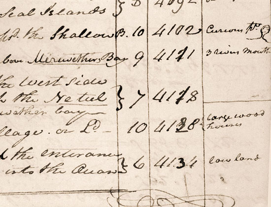
| to the Cath-lâh-mâh Town of | } | 8 | 4092 | on high land | |
| 9 houses South of the Seal | |||||
| Islands | |||||
| to Point William
opsd. the Shallow B. |
10 |
4102 |
Curious pt. [23] |
||
| to Point Meriwether
above Meriwethers Bay |
9 |
4111 |
3 rivers mouth |
||
| to Fort Clâtsop on the west | } | 7 | 4118 | ||
| side of and 3 miles up the | |||||
| Netul river from Meriwether | |||||
| bay | |||||
| to the
Clât sop
Village on Ld.— |
10 |
4128 |
large wood houses |
||
| to Point Adams at the enter- ance of the Columbia into the Ocian |
6 |
4134 |
low land |
||
| On the Sea coaste to the S. S. E from point Adams [24] | |||||
| to
Ne er cawan a ca Creek & village |
8 |
3 houses |
|||
| to the enterance of Clât-sop | } | 9 | 3 old towns | ||
| river at 3 houses remains of | |||||
| an old vilg. | |||||
| to the Salt works at the foot | } | 2 | Canoe Vaults | ||
| of a mountain near 4 houses | |||||
| to the most projicted part of | } | 7 | one rock out | ||
| the Mountain of Clarks point | |||||
| of view of 1000 feet above | |||||
| the leavel of the water | |||||
| to an old Kil â mox Village | 3 | no. of rocks out | |||
| to the mouth of E-cu-la or | } | 6 | do— do | ||
| whale Creek 35 yds wide, and | |||||
| 4 huts of Kil a mox boiling | |||||
| whale blubber | |||||
| to 6 huts of Kil á mox boiling blubber |
2 |
do— do |
|||
| to the Great Kil á mox Town | } | 20 | Inds. net a Sand bar do | ||
| at the enterance of Ni-ê-lee | |||||
| Creek | |||||
| to Kil-her-hurst's Town of Kil | } | 5 | a rock in entrs— | ||
| á mox at the Enterance Kil a | |||||
| mox Bay | |||||
| to Kil-her-ner's town of Kil a | } | 2 | on the bay | ||
| mox on the Bay at the mouth | |||||
| of a Creek | |||||
| to Chish ucks town of Kil â | } | 2 | heads near Columbia | ||
| mox at the Enterance of Kila- | |||||
| mox river which is about | |||||
| 100 yds | |||||
| to Tow-er-quot tons Creek & Town |
2 |
||||
| 68 | |||||
| to
Chuck tins
Town and Creek at the bottom of the Bay which I call Kilámox Bay) [25] |
2 mile |
||||
| Miles | 70 | ||||
Oregon, Winter 1805–6, Codex I, p. 11
note ☞ 30 miles of this coast is from the information of Indians, collected from differint persons. They further inform me that the Kil á mox have two Small villages on the Kil á mox river, it is very rapid without any purpindicular falls, that nation pass across from the head of this little river to the Columbian Vally, which is at no Great Distance from its head at Wap pa to Island and pass down the Chock-âh lil' com or Columbia river with the Wappato they purchase.
notes from the Mouth of Columbia.
| To the Wappato Island, Center is | S. 20° E | 108 miles |
| To quick Sand river is— | S. 32° E | 121 " |
| to the grand rapids is— | S. 47° E | 128 " |
| to the Great falls is— | S. 65° E | 172 " |
| to the Mouth of Lewis's river | East | 240 " |
From the Mouth of Lewis'es river [26]
| to the Mouth of Kooskooske is | N. 52° E | 96 miles | |
| to the Mouth of Cho-pun-nish R | } | East | 144 Miles |
| at the Canoe Camp is— | |||
| to the long Shute or narrows above | N. 28° E. | 55 Mile |
LEWIS AND CLARK'S POINTS FROM FORT MANDAN TO THE PACIFIC COAST
| To the foot of the Mountain is | S. 85 E | 28 miles | |
| To Travelers rest over monts. | N 80° E. | 107 miles | |
| From Travelers rest to the dividing ridge at Snake Indian | } | S 24 E | 175 miles |
| portage or Lewis's portage from Jeffersons R | |||
| From Travelers rest creek to pine Island rapid comesmt | } | S 85 E | 99 miles |
| [commencement?] of Mtns. |

